
Search
Did you mean: Bes?
Remove Ads
Advertisement
Search Results

Image
Latin Surrender to Saladin, 1187 CE
A painting depicting the surrender of the Latin ruler Guy de Lusignan to Saladin, the Sultan of Egypt and Syria (r. 1174-1193 CE), after the battle of Hattin in 1187 CE. The loss and subsequent capture of Jerusalem by Saladin would spark...

Image
Anglo-Saxon Clothing, 6-9th century CE
An illustration of the typical clothing worn by Anglo-Saxons in medieval England, c. 500 - c. 1000 CE. ('Costumes of all Nations', 1882 CE)
Image
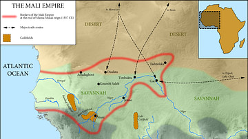
Map of the Mali Empire, c. 1337 CE
A map of the Mali Empire (1240-1645 CE) at its peak c. 1337 CE after the reign of Mansa Musa (1312-1337 CE).

Image
The Barracks Emperors of Rome, 235 - 284 CE - Military Power and Imperial Instability
The period of the “Barracks Emperors” coincides with the Crisis of the Third Century (235–284 CE), one of the most turbulent phases in Roman history. Beginning with the assassination of Severus Alexander (reign 222–235 CE), imperial authority...

Image
Map of the Roman Rule in the Levant, c. 200 CE
The Roman Levant around 200 CE, during the height of imperial consolidation under the Severan dynasty (193 - 235 CE), formed one of the empire’s most dynamic and interconnected frontier regions. Administratively divided into the provinces...

Image
Map of the Iron Age La Tène Culture c.400 BCE - c.50 CE
This map illustrates the extent of the La Tène culture, a key phase of the European Iron Age that flourished from around 450 BCE until the Roman conquests in the 1st century BCE. It highlights the widespread influence of early Celtic societies...

Image
Umayyad Conquest, 7th & 8th Centuries CE
Map showing the Umayyad Arab (Islamic) expansion throughout the 7th and 8th centuries CE. In dark green is depicted the extent of Islam up until the death of Mohammed (622-632 CE); in the intermediate green is shown the conquests of Rashidun...

Image
Map of the Kingdom of the Vandals (435–534 CE)
The Kingdom of the Vandals and Alans (435–534 CE) emerged as one of the most significant post-Roman states in the western Mediterranean. Founded after the Vandals, a Germanic people originally from Central Europe, and the Alans, an Iranian-speaking...
Image
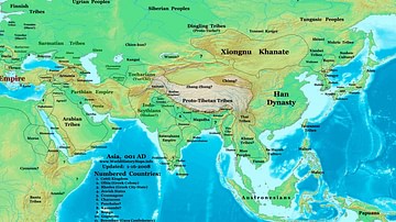
Map of the Eastern Hemisphere (1 CE)
Map showing the political division in the Eastern hemisphere in 1 CE. The Han dynasty was almost at its peak in terms of geographical expansion.

Image
Great Viking Army in England, 865-878 CE
Map showing the routes allegedly taken by the Great Viking Army that invaded the Anglo-Saxon Kingdoms in 865 CE, under leadership of such chieftains as 'Hingwar', 'Hubba', and 'Halfdene' (Anglo-Saxon Chronicle for 870-871 CE). These figures...