


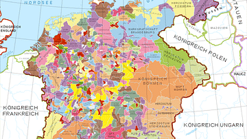
Map of the Holy Roman Empire depicting its boundaries following the Peace of Westphalia in 1648 CE.
Related Images

Map of Europe at the Peace of Westphalia, 1648 - From the Thirty Years’ War to a New European Order

Map of the Holy Roman Empire under Otto the Great c. 972

Map of the Holy Roman Empire, 972-1032 CE
Holy Roman Empire in the 13th century CE

Map of the Provinces of the Roman Empire under Augustus

Map of the Achaemenid Persian Empire c. 500 BCE
Cite This Work
APA Style
Astrokey44. (2021, March 22). Map of the Holy Roman Empire, 1648 CE. World History Encyclopedia. https://www.worldhistory.org/image/13699/map-of-the-holy-roman-empire-1648-ce/
Chicago Style
Astrokey44. "Map of the Holy Roman Empire, 1648 CE." World History Encyclopedia, March 22, 2021. https://www.worldhistory.org/image/13699/map-of-the-holy-roman-empire-1648-ce/.
MLA Style
Astrokey44. "Map of the Holy Roman Empire, 1648 CE." World History Encyclopedia, 22 Mar 2021, https://www.worldhistory.org/image/13699/map-of-the-holy-roman-empire-1648-ce/.