
Server Costs Fundraiser 2026


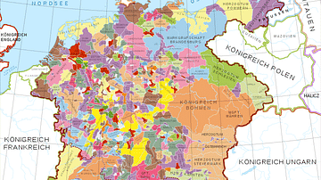
Map of the Holy Roman Empire depicting its boundaries under the rule of Otto I in 972 CE and Conrad II in 1032 CE.
Related Images

Map of the Holy Roman Empire under Otto the Great c. 972

Map of the Holy Roman Empire, 1648 CE
Holy Roman Empire in the 13th century CE

Map of the Provinces of the Roman Empire under Augustus

Map of the Roman Empire under Theodosius the Great, c.395 - The Last Unified Roman Empire

Map of the Fall of the Western Roman Empire, c. 480 CE
Cite This Work
APA Style
Sémhur. (2021, March 22). Map of the Holy Roman Empire, 972-1032 CE. World History Encyclopedia. https://www.worldhistory.org/image/13698/map-of-the-holy-roman-empire-972-1032-ce/
Chicago Style
Sémhur. "Map of the Holy Roman Empire, 972-1032 CE." World History Encyclopedia, March 22, 2021. https://www.worldhistory.org/image/13698/map-of-the-holy-roman-empire-972-1032-ce/.
MLA Style
Sémhur. "Map of the Holy Roman Empire, 972-1032 CE." World History Encyclopedia, 22 Mar 2021, https://www.worldhistory.org/image/13698/map-of-the-holy-roman-empire-972-1032-ce/.