
Search
Did you mean: Bes?
Remove Ads
Advertisement
Search Results
Image
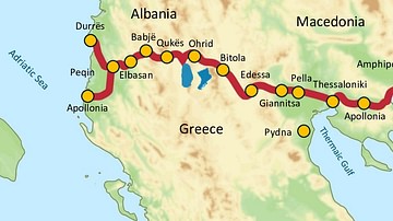
Via Egnatia, 146 BCE to c. 1200 CE
Via Egnatia was a major Roman road in the Balkans, stretching 1,120 kilometers (696 miles) from the Adriatic Sea in the west to the Black Sea and the Sea of Marmara in the east. The western terminus is slightly uncertain, often marked in...

Image
Map of the Empire of Timur the Lame, c. 1404 CE
This map illustrates the rise and expansion of the Timurid Empire (1370–1405) under Timur (Tamerlane), a conqueror of Turco-Mongol descent whose military campaigns reshaped the political landscape of 14th-century Eurasia. Born in 1336 near...

Image
Map of the Fall of the Western Roman Empire, c. 480 CE
The disintegration of the Western Roman Empire unfolded gradually during the Migration Period (c. 400–800 CE), as waves of migrating and invading peoples reshaped Europe. After the death of Theodosius I (reign 379–395 CE), the last emperor...

Image
The Greatest Extent of the Ottoman Empire in Europe (1683 CE)
A depiction of the Ottoman Empire and its dependencies in 1683 CE, with an indication of territory held prior to that date.

Image
Spread of Christianity Map (up to 600 CE)
Map showing the spread of Christianity, showing both strongly Christianized areas before 325 CE and generally Christianized areas until 600 CE. The map also shows major Christian centers and the cities in which Christian councils were held.

Image
Map of Roman Gaul from Conquest to Integration, c. 200 CE - Provincial Order and Frontier Power in the Roman West
The Roman incorporation of Gaul began with the campaigns of Julius Caesar (58–51 BCE) and resulted in the gradual transformation of a diverse Celtic region into an integral part of the Roman world. By c. 200 CE, Gaul was organized into a...

Image
Map of the Roman Empire in 125 CE
A map of the Roman Empire and Europe in 125 CE, at the time of Roman emperor Hadrian.
"Barbarian" names and locations are given as found in the works of Tacitus (written c. 100 CE).

Image
The Five Good Emperors of the Roman Empire (96 - 180 CE)
This infographic illustrates the succession of Roman emperors from 96 to 180 CE, commonly referred to as the Five Good Emperors - Nerva, Trajan, Hadrian, Antoninus Pius, and Marcus Aurelius. This term, unknown to the Romans themselves, was...

Image
Map of the Empire of the Huns under Attila, c. 450 CE - Power, Pressure, and Collapse in Late Antiquity
The rise of the Huns in the 5th century CE reshaped the political landscape of Late Antiquity, culminating under Attila the Hun (reign 434-453 CE). Emerging from the Eurasian steppe, the Huns did not form a centralized territorial state in...

Image
Trade in the Roman Empire Map (c. 200 CE)
This map shows the major sources of trade goods in the Roman Empire, circa 200 CE. The map shows the sources of the following trade goods: grain, olive oil, slaves, wine, metals, textiles and wild animals.