
Search
Did you mean: Bes?
Remove Ads
Advertisement
Search Results

Image
Map of Armenia, 50 CE
Map of Armenia and the Roman client states in eastern Asia Minor, ca. 50 CE, before the Roman-Parthian War and the annexation of the client kingdoms into the Empire.

Image
Roman Province Bithynia et Pontus c. 200 CE
The Roman province of Bithynia et Pontus, established in 63 BCE after the defeat of Mithridates VI of Pontus, was a prosperous and strategically significant region by 200 CE. Located in northern Anatolia along the southern Black Sea coast...

Image
Major Temples and Shrines of Japan circa 1200 CE, Kamakura Shogunate
This map depicts all major Buddhist temples and Shinto shrines of Japan around the year 1200 CE. Notice that many renowned temples (such as the famous Kinkaju-ji) have not yet been built at that time. The map highlights the city of Kamakura...

Image
Fresco Showing the Riot of 59 CE in the Amphitheatre of Pompeii
Fourth Style fresco depicting a riot that broke out in Pompeii in 59 CE during games held in the arena involving Pompeians and inhabitants of Nuceria. On the orders of Nero, this event led to the closure of the amphitheatre for ten years...

Image
Paul the Apostle's First Missionary Journey (c. 46-48 CE)
Paul the Apostle undertook multiple missionary journeys across the Roman Empire to spread Christianity, establish churches, and strengthen the faith of early Christians. Paul's first missionary journey, accompanied by Barnabas and John Mark...

Image
Map of the Middle East during the Second Fitna (c. 686 CE)
A map depicting the divisions of the Islamic Empire during the second Islamic civil war - the Second Fitna. The dominions of the Umayyads, Zubayrids, Kharjites, Al Mukhtar and those regained by the Byzantines are shaded in colors as indicated...

Image
The Mongol Scroll, 1293 CE
The Mongol Scroll, aka the 'Illustrated Account of the Mongol Invasion of Japan.' Commissioned by Takezaki Suenaga, a samurai warrior who fought during the Mongol invasions of Japan in 1274 and 1281 CE, the painted scroll was produced in...
Image
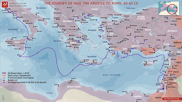
Paul the Apostle's Journey to Rome (c. 60-63 CE)
Paul the Apostle undertook multiple journeys across the Roman Empire to spread his teachings, establish communities, and support early Christian groups. Paul's journey to Rome, undertaken as a prisoner appealing his case to the Roman emperor...

Image
Map of Diaspora Synagogues (1st - 2nd centuries CE)
This map illustrates the geographic spread of Jewish communities and synagogues across the Roman and Parthian worlds during the 1st and 2nd centuries CE. It highlights the development of Jewish life in the Diaspora following centuries of...

Image
Map of the Bosporan Kingdom, c.100 CE - Gateway Between Steppe, Caucasus, and Rome
The Bosporan Kingdom (c. 480 BCE–341 CE) emerged around the Cimmerian Bosporus (modern Kerch Strait) as a hybrid Greco-local state founded by Greek colonists from cities such as Miletus. Rather than a single unified polity in the modern sense...