
Search
Did you mean: Bes?
Remove Ads
Advertisement
Search Results
Image
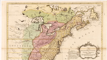
English & French Colonies in North America, 1758 CE
Map of English and French colonies in North America c. 1758 CE. English-controlled colonies are shown in yellow, French colonies in green, and disputed territories in red. Collection of the Library of Congress, Washington, D.C.

Image
Map of the Year of the Four Emperors, 69 CE
The Year of the Four Emperors (69 CE) was a moment of deep instability in the Roman Empire, marked by the rapid succession of Galba (June 68–January 69 CE), Otho (January–April 69 CE), Vitellius (April–December 69 CE), and Vespasian (69–79...

Image
Khmer Empire c. 900 CE
A map illustrating in red the Khmer Empire c. 900 CE.
Image
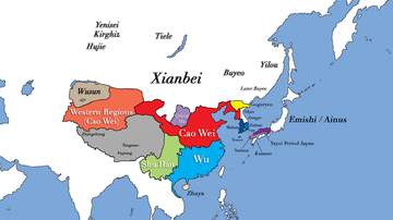
Three Kingdoms Period of China and the Rise of Xianbei in the year 229 CE
This map depicts the boundaries of all major civilizations in East Asia at the beginning of the Three Kingdoms Period of China, with italics indicating nomadic bands and other tribal societies. Following the collapse of Han Dynasty in 220...

Image
Map of New France, 1750 CE
A map of New France c. 1750 CE within the context of European colonies in North America.

Image
The Venetians Attack Constantinople, 1204 CE
A 16th century CE painting by Domenico Tintoretto depicting the Venetians attacking the sea walls of Constantinople in 1204 CE during the Fourth Crusade.

Image
Map of the Byzantine Empire in 1025 CE
Map of the provinces of the Byzantine Empire in 1025 CE.
Image
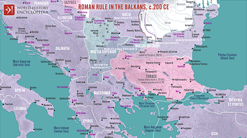
Roman Rule in the Balkans, c. 200 CE
A map illustrating Roman rule in the Balkans around 200 CE, characterized by significant administrative, military, and cultural integration into the Empire. The region was divided into several provinces (Moesia Superior, Moesia Inferior...

Image
Ottoman Infantry Coat of Arms (1882-1922 CE)
A typical military sign from the Ottoman Empire known as "arma" (this Homeric Greek expression itself reflects a symbol adopted under influence from abroad). Used in the Turkish army (infantry) and displayed on the reverse side of the battalion...

Image
Map of the Crusader States, 1229-1240 CE
A map indicating the territories controlled by the Crusader States or Latin East from 1229 CE to 1240 CE after the Sixth Crusade (1227-1229 CE)