
Search
Did you mean: Bes?
Remove Ads
Advertisement
Search Results

Image
Map of the Roman Empire under the Flavians (69–96 CE) - Stability after Civil War
The territorial organization of the Roman Empire at the close of the Flavian dynasty (69–96 CE) reflects a period of consolidation following the political crisis that ended the Julio-Claudian line. After the turmoil of the Year of the Four...
Image
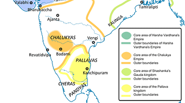
Ancient India in 625 CE
This is a political map of India showing the important kingdoms that existed around 625 CE. The predominant powers are the Pushyabhutis under Emperor Harshavardhana or Harsha (606-647 CE) in northern India, the (Vatapi) Chalukyas under Emperor...

Image
Cities Founded or Renamed in Hadrian’s Name (117 -138 CE)
During the reign of Emperor Hadrian (reigned 117–138 CE), urban patronage became a central tool of imperial governance and representation. Unlike his predecessor Trajan, whose rule emphasized territorial expansion, Hadrian focused on consolidation...

Image
13th Century CE Roll of Arms
The oldest known English roll of arms, dating to c. 1244 CE. It is a single sheet painted on both sides by Mathew Paris and showing 75 coats of arms starting with the king’s. (British Library, London)

Image
Northern Crusades, 1260-1410 CE
A map indicating the territories controlled by the Teutonic Knights military order and their Crusades against pagan Europeans in the 13th and 14th century CE.

Image
English Medieval Clothing, c. 1300 CE
An illustration of the typical clothing worn in 14th century CE England. ('Costumes of all Nations', 1882 CE)
Image
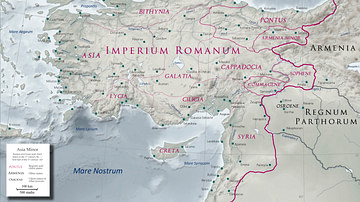
Asia Minor in the Early 1st Century CE
Map of Asia Minor in the early 1st century CE with the Kingdom of Commagene as a Roman client state.
Image
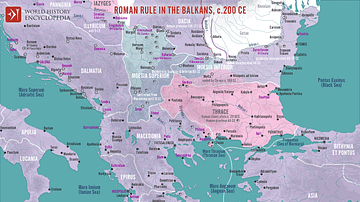
Roman Rule in the Balkans, c. 200 CE
A map illustrating Roman rule in the Balkans around 200 CE, characterized by significant administrative, military, and cultural integration into the Empire. The region was divided into several provinces (Moesia Superior, Moesia Inferior...
Image
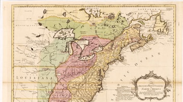
English & French Colonies in North America, 1758 CE
Map of English and French colonies in North America c. 1758 CE. English-controlled colonies are shown in yellow, French colonies in green, and disputed territories in red. Collection of the Library of Congress, Washington, D.C.

Image
Map of the Year of the Four Emperors, 69 CE
The Year of the Four Emperors (69 CE) was a moment of deep instability in the Roman Empire, marked by the rapid succession of Galba (June 68–January 69 CE), Otho (January–April 69 CE), Vitellius (April–December 69 CE), and Vespasian (69–79...