
Search
Search Results

Image
Map of Romani Migration in the Middle Ages
Map showing the movement of the Romani people between approximately 500 and 1500 CE. The dates used on this map are commonly accepted approximations based on historical accounts and linguistic evidence. Some dates, such as the timeframe in...

Image
Map of the Russian Empire on the Eve of World War I, 1914 - A Eurasian Giant at the Brink
The Russian Empire on the eve of World War I (1914) represented the largest contiguous empire in modern history, stretching from Eastern Europe across Siberia to the Pacific Ocean. Its territorial scale was the result of gradual expansion...

Image
Map of the Holy Roman Empire, 972-1032 CE
Map of the Holy Roman Empire depicting its boundaries under the rule of Otto I in 972 CE and Conrad II in 1032 CE.
Image
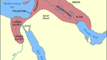
Map of the Fertile Crescent
This map shows the location and extent of the Fertile Crescent, a region in the Middle East incorporating ancient Egypt; the Levant; and Mesopotamia.

Image
Transatlantic Triangular Trade Map
Map showing the flow of goods and enslaved people across the Atlantic between Europe, Africa and America in the transatlantic triangular trade which the European colonial powers operated from the 16th to the 19th centuries CE. This triangular...

Image
Map of the American Civil War, 1861-1865
The American Civil War (1861–1865) was a nationwide conflict in the United States sparked by the secession of eleven Southern states following Abraham Lincoln’s election in 1860. The Confederacy, founded on the preservation of slavery, clashed...

Image
Map of the Mauryan Empire, c. 321 - 185 BCE
A map illustrating the rise and expansion of the Mauryan empire, the first pan-Indian empire that covered most of India and parts of present-day Iran. Chandragupta Maurya, the first ruler, seized the opportunity created by the power vacuum...

Image
Map of the Mali Empire under Mansa Musa, c.1337 - Power, Gold, and the Trans-Saharan Trade Network
The Mali Empire (c. 1235 - c. 1672) emerged in the western Sahel following the decline of the Ghana Empire and rose to prominence under the leadership of Sundiata Keita (reigned c. 1235 - 1255). Consolidating Mandé-speaking territories along...

Image
Map of the British Conquest in India c. 1857
This map illustrates the rapid and often chaotic expansion of British control in India between the Battle of Plassey in 1757 and the eve of the Indian Rebellion in 1857. During this century, the East India Company transformed from a trading...

Image
Map of the Empire of Timur the Lame, c. 1404 CE
This map illustrates the rise and expansion of the Timurid Empire (1370–1405) under Timur (Tamerlane), a conqueror of Turco-Mongol descent whose military campaigns reshaped the political landscape of 14th-century Eurasia. Born in 1336 near...