
Search
Search Results

Image
Map of Japan in the 16th Century CE
A map of Japan during the Azuchi-Momoyama period (1568-1600 CE).

Image
Map of the World of the Iliad, c. 1200 BCE
The key locations, kingdoms, and heroes associated with Homer’s Iliad form a cultural map of the Late Bronze Age Aegean world. Composed in the 8th century BCE and set in the final year of the war between the Achaean coalition and the city...

Image
Map of Spanish Conquest & Exploration in North America
This map illustrates the expansion of Spanish imperial power following the completion of the Reconquista in 1492 and the voyages of Christopher Columbus (first voyage 1492). Fueled by promises of land, gold, and glory, Spain launched one...

Image
Map of Europe at the End of World War I, November 1918 - Lost Empires, Uncertain Borders, and New Nations
This map illustrates the geopolitical landscape of Europe in mid-November 1918, immediately after the signing of the Armistice of Compiègne (11 November 1918), which ended the First World War (1914–1918). The Great War, fought on an unprecedented...

Image
Map of Spanish Main & West Indies c.1720 - Spain, France, England, and the Dutch in a Struggle Over Trade, Treasure, and Empire
This map captures the shifting tides of colonial power in the 1700s, focusing on the strategic coastlines of the Caribbean Sea and the Gulf of Mexico. Once dominated by Spain, this region—known as the Spanish Main and the West Indies—became...

Image
Map of Europe on the Eve of World War I, Early 1914
Europe on the eve of World War I was defined by a volatile mix of alliance politics, imperial rivalry, and rising nationalism. The continent was divided into two heavily armed blocs, the Triple Alliance and the Triple Entente, binding the...

Image
Map of the European Colonization of North America, 1492-1750
The systematic European colonization of North America unfolded between the first voyages of the 1490s and the outbreak of the French and Indian War in the 1750s. Spanish, French, English, and Dutch ambitions carved up the continent, with...

Image
Map of the United States on the Eve of Civil War, 1861
In early 1861, the United States entered the most severe constitutional and political crisis in its history. The election of Abraham Lincoln (president 1861–1865) triggered a wave of secessions beginning with South Carolina in December 1860...

Image
Map of the Movement of "Tea" & "Cha" Around the Globe
This map illustrates the global spread of tea and its many names, tracing how two primary root words—“cha” and “te”—originated in China and dispersed across cultures through trade. The linguistic patterns reveal how tea’s journey followed...
Image
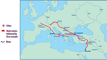
Map of the First Crusade Routes
"This map shows the main routes taken by those who joined the First Crusade. The appeal was made by Pope Urban II in November 1095 CE but crusaders did not set out until the following summer. One route went through Hungary crossing the Byzantine...