
Search
Search Results
Image
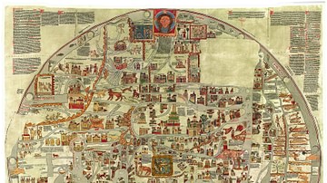
Ebstorf Map
The Ebstorf Map is a Medieval world map made by Gervase of Ebstorf c. 1234-1240. The original map was destroyed in 1943 during World War II, but several color facsimiles (including this image) survive.

Image
Map of Ancient Egypt
Map of ancient Egypt, showing the major cities and archaeological sites along the Nile River, from Abu Simbel in the south to Alexandria in the north .

Image
Map of the Islamic Conquests in the 7th-9th Centuries
This map illustrates the rise and rapid expansion of Islam from the time of the Prophet Muhammad (622–632 CE) through the great caliphates of the 7th to 9th centuries. Beginning in Arabia, the new faith and its armies spread under the Rashidun...

Image
Map of Odysseus’ 10-year Journey Home
The Odyssey, traditionally attributed to Homer and composed around the 8th–7th century BCE, recounts the decade-long journey of Odysseus, king of Ithaca, as he attempts to return home after the Trojan War. Although set in a recognizable Mediterranean...
Image
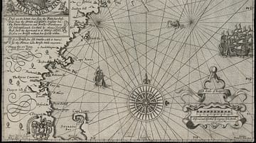
Map of New England
Map of New England by Captain John Smith
Printed by Geor. Low, 1624 CE
Based on Smith's 1614 CE voyage, this is the first printed map to use the name “New England” for the region and was used by the pilgrims who founded Plymouth Colony.
Image
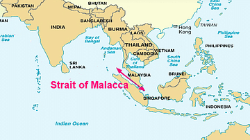
Map of the Strait of Malacca
A map showing the Strait of Malacca in Malaysia which links the Indian Ocean (the Andaman Sea) to the South China Sea. The strait was a particularly important maritime route for the Spice Trade from the 15th century and was controlled by...

Image
Map of the Achaemenid Persian Empire c. 500 BCE
The Achaemenid Persian Empire emerged in the mid-6th century BCE when Cyrus II (reign 559–530 BCE) united the Persian tribes and overthrew the Median kingdom (c. 550 BCE), establishing a new imperial state that would reshape the political...

Image
Map of the Provinces of the Roman Empire under Augustus
This map illustrates the expansion of the Roman Republic during the military campaigns and conquests of Julius Caesar (100–44 BCE), and its transformation into an empire under the reign of Caesar Augustus (63 BCE–14 CE), also known as Octavian...
Image
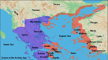
Map of Archaic Greece
A map of the political structure of Greece in the Archaic Age (ca. 750 - 490 BC).

Image
Map of the World in the 14th Century
The 14th century was a time of crisis and transformation across much of the world. Plague, war, shifting power structures, and intellectual ferment reshaped societies from Asia to Africa, Europe to the Americas. Despite profound instability...