
Search
Search Results

Image
Map of the inca Empire
A map showing the various stages of expansion of the Inca empire.

Image
Map of the Trade Networks in the Middle Ages, c. 1200
By the early 13th century (c. 1200 CE), long-distance trade networks across Eurasia and the Mediterranean had regained a level of interconnectivity not seen since late antiquity. After the political fragmentation that followed the fall of...
Image
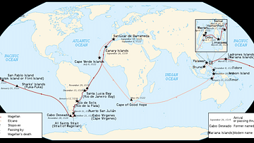
Map of Ferdinand Magellan's Circumnavigation
A map of the 1519-22 circumnavigation - the first in history - made by the expedition led by the Portuguese navigator Ferdinand Magellan (c. 1480-1521).

Image
Map of Mesopotamia, 2000-1600 BCE
A general map of Mesopotamia and its neighbouring territories which roughly covers the period from 2000-1600 BCE reveals the concentration of city states in Sumer, in the south. This is where the first true city-states arose, although...

Image
Map of the US-Mexican War of 1846-1848
The U.S.–Mexican War (1846–1848) marked a decisive moment in the territorial and political transformation of North America. The conflict was triggered by the U.S. annexation of Texas (1845) and a disputed southern boundary, claimed by the...

Image
Map of Roman North Africa (146 BCE - 395 CE)
This map illustrates the scope and administrative organization of the Roman provinces in North Africa, from the initial conquest in 146 BCE to their full integration into the empire. Following the destruction of Carthage at the end of the...

Image
Map of the Roman Conquest of Italy
This map shows the Roman conquest of Italy from 500 BCE to 218 BCE.

Image
Map of the Peloponnesian Wars (431-404 BCE)
This map shows Greece, Asia Minor and Sicily during the Peloponnesian Wars. The main powers of Athens, Sparta and their allies, as well as Achaemenid Persia and neutral states, are highlighted. Key battles are indicated by an X and military...

Image
Map of Anglo-Saxon London
This is a map of Anglo-Saxon London between circa 500 CE and 1066 CE. The main purpose of this map is to highlight those place names which can still be recognized in modern London. As this map spans over 500 years, some of these places may...

Image
Medieval Baltic Populations Map - c. 1200 CE
Baltic Tribes c. 1200, map by Mapmaster, January 2007 A map depicting the population groups inhabiting the Baltics in around 1200 CE. Borders shown are aproximations. Based on a map by Marija Gimbutas, published in The Balts (1963) LCC 63018018...