
Search
Search Results

Image
Map of the Louisiana Purchase
This map illustrates the geo-political situation in North America after The Louisiana Purchase - the 1803 acquisition by the United States of 828,000 square miles (2,144,000 square km) of French territory west of the Mississippi River. By...
Image
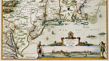
New Netherland Map
A map of New Netherland published by Nicolaes Visscher II (1649–1702) in 1684. This map is partially a copy of the map by Jan Janssonius (1588-1664) from 1651.

Image
Map of Jeanne d'Arc's Route & The Hundred Years' War c. 1429
This map illustrates the Hundred Years’ War (1337–1453) at its pivotal moment in 1429, when Joan of Arc’s (French: Jeanne d'Arc) whirlwind campaign shifted momentum toward the Dauphin, Charles VII of France (reigned 1422–1461). It contrasts...

Image
Map of the Indus Valley Civilization, c. 3300-1300 BCE - Cities, Trade, and Settlement in the Bronze Age
The Indus Valley Civilization (c. 3300–1300 BCE) was one of the earliest complex societies of the Bronze Age world, extending across parts of present-day Pakistan and northwestern India. Its most developed phase, often called the Mature Harappan...

Image
Map of Mesopotamia and the Ancient Near East, c. 1300 BCE
Map of Mesopotamia and the Ancient Near East c. 1300 BCE, showing the period of Great Powers, with the six large kingdoms and empires (the Hittites, the Mycenaean Civilization, Assyria, Babylonia, Elam and the New Kingdom of Egypt) co-existing...
Image
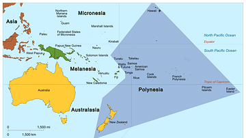
Map of Polynesia
Map showing the Polynesian Triangle and some of its islands.
Image
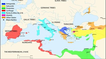
Map of the Mediterranean 218 BCE
A map of the Mediterranean in 218 BC, showing the territorial extents of the following states:
- Antigonids
- Attalids
- Carthage
- Ptolemies
- Roman Empire
- Seleucids
Major battle locations are also shown.

Image
Map of the USA Expansion after the Treaty of Paris in 1783
This map illustrates the expansion of the United States from the Treaty of Paris (1783) to the mid-19th century, a period in which the young republic transformed from thirteen coastal states into a nation spanning the breadth of North America...
Image
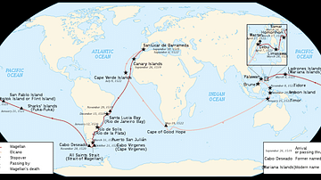
Map of Ferdinand Magellan's Circumnavigation
A map of the 1519-22 circumnavigation - the first in history - made by the expedition led by the Portuguese navigator Ferdinand Magellan (c. 1480-1521).

Image
Map of the East India Company Trade, c.1800
The English East India Company (EIC) was established by Royal Charter on 31 December 1600 under Queen Elizabeth I (reign 1558–1603), granting it a monopoly on English trade east of the Cape of Good Hope. Initially conceived as a commercial...