
Search
Search Results

Image
Map of Viking Exploration, 8th-11th Century
This map illustrates the sweep of Viking exploration between the late 8th and early 11th centuries, charting longship routes from Scandinavia to the British Isles, Normandy, Iberia, Russia, the Mediterranean, and across the North Atlantic...

Image
Map of Marco Polo’s Travels, 1271 - 1295
Marco Polo’s travels (1271–1295) represent one of the most famous European journeys into Asia during the late Middle Ages. Setting out from Venice with his father Niccolò and uncle Maffeo, Polo crossed through the Middle East and Central...

Image
Map of WWII North Africa Campaign, 1940-1943
The North Africa Campaign (1940–1943) formed a decisive theater of the World War II (1939–1945), centered on control of the strategic corridor linking the Mediterranean Sea to the Suez Canal and the Middle Eastern oil fields. The conflict...

Image
Map of the Warring States of China & Qin Conquest
The Warring States period (c. 475–221 BCE) represents the final and most transformative phase of the Eastern Zhou dynasty (770–256 BCE), marked by political fragmentation, sustained interstate warfare, and profound institutional change. As...

Image
Map of the Rise and Fall of Carthage (c. 650-146 BCE)
Carthage (c. 814–146 BCE) emerged as the leading Phoenician power in the western Mediterranean following its foundation by settlers from Tyre around c. 814 BCE. Built on maritime trade, naval dominance, and a dense network of colonies across...

Image
Map of Canaan
A map of Canaan with the boundaries as indicated in the Bible's books of Numbers and Ezekiel.
Image
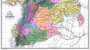
Map of Gran Colombia
A map of the Republic of Colombia (1819-1831), a state that covered much of northern South America after independence from the Spanish Empire, by Agostino Codazzi, 1840. The map depicts the Republic of Colombia divided into 12 administrative...

Image
Map of the Roman Trade Network (1st - 3rd centuries CE)
This map illustrates the main maritime and overland trade arteries that bound the Roman Empire together between the first and third centuries CE. From grain fleets in the Mediterranean to camel caravans across the desert and river barges...

Image
Map of the Byzantine Empire, c.520 - 1204
This map illustrates the shifting frontiers of the Byzantine Empire from the accession of Justinian I (reign circa 527 - 565) to the Fourth Crusade's sack of Constantinople in 1204, showing how the Greek-speaking eastern Roman state acted...
Image
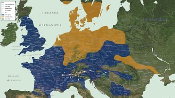
Map of Celtic and Germanic Tribes
This map shows the various Celtic and Germanic tribes around circa 52 BCE.