


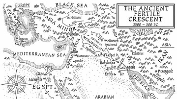
This map shows the location and extent of the Fertile Crescent, a region in the Middle East incorporating ancient Egypt; the Levant; and Mesopotamia.
Related Images

Map of the Fertile Crescent

Fertile Crescent Map
A Map of the Ancient Fertile Crescent (From the Novel The Jericho River)

Map of Southern Levant c.1200 BCE - Emerging Societies in the Early Iron Age

Map of the Roman Rule in the Levant, c. 200 CE

Map of the Herodian Tetrarchy in the Levant, c. 5 CE
Cite This Work
APA Style
NormanEinstein. (2012, April 26). Map of the Fertile Crescent. World History Encyclopedia. https://www.worldhistory.org/image/169/map-of-the-fertile-crescent/
Chicago Style
NormanEinstein. "Map of the Fertile Crescent." World History Encyclopedia, April 26, 2012. https://www.worldhistory.org/image/169/map-of-the-fertile-crescent/.
MLA Style
NormanEinstein. "Map of the Fertile Crescent." World History Encyclopedia, 26 Apr 2012, https://www.worldhistory.org/image/169/map-of-the-fertile-crescent/.