

This text is available in other languages:

The term “Fertile Crescent”, coined in 1916 by Egyptologist James Henry Breasted, refers to a broad arc of land stretching from the eastern Mediterranean through Anatolia and into Mesopotamia. Encompassing parts of today’s Iraq, Syria, Lebanon, Israel, Palestine, Jordan, Turkey, and western Iran, this region earned its name due to its unusually rich soils, varied ecosystems, and river systems, most notably the Tigris and Euphrates. Archaeological evidence shows that by the 9th millennium BCE, communities had shifted from mobile foraging to settled agriculture, cultivating early cereals such as wheat and barley and domesticating animals including sheep, goats, and pigs. These environmental and technological advantages created the material foundations for population growth, social differentiation, and increasingly complex forms of community organization.
Over time, the Fertile Crescent became a catalyst for the rise of some of the world’s earliest urban and state-level societies. Surplus food production enabled specialization, long-distance trade networks, and the emergence of administrative and religious institutions that shaped early political authority. This process culminated in the rise of urban centers in Sumer, Akkad, Assyria, and later the Levant, polities whose innovations in writing, law, irrigation, and governance left a lasting imprint on human history. Although the term “Fertile Crescent” reflects a modern framing, it underscores the region’s long continuity as a crossroads of cultures and ideas, highlighting how geography, environment, and human adaptation interacted to create one of the most influential developmental cores of the ancient world.
About the Author

Related Images
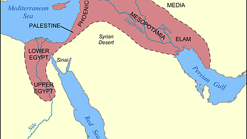
Map of the Fertile Crescent

Fertile Crescent Map
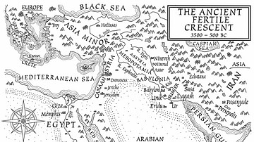
A Map of the Ancient Fertile Crescent (From the Novel The Jericho River)

Map of Sumer

Map of Sumer and Elam

Possible Agricultural Centers in Prehistoric China
Cite This Work
APA Style
Netchev, S. (2020, August 05). Map of the Fertile Crescent. World History Encyclopedia. https://www.worldhistory.org/image/12521/map-of-the-fertile-crescent/
Chicago Style
Netchev, Simeon. "Map of the Fertile Crescent." World History Encyclopedia, August 05, 2020. https://www.worldhistory.org/image/12521/map-of-the-fertile-crescent/.
MLA Style
Netchev, Simeon. "Map of the Fertile Crescent." World History Encyclopedia, 05 Aug 2020, https://www.worldhistory.org/image/12521/map-of-the-fertile-crescent/.