


The rise and expansion of the Carolingian dynasty (8th–early 9th centuries CE) reached its apex under Charlemagne (reigned 768–814 CE), son of Pepin the Short (reigned 751–768 CE) and grandson of Charles Martel (d. 741 CE). Building on earlier Frankish consolidation, Charlemagne pursued sustained military campaigns that transformed a regional kingdom into the most powerful polity in Western Europe since the fall of the Western Roman Empire. Through conquest and coercive integration, Carolingian authority extended into northern Iberia, across Gaul, deep into Germanic lands as far as the Elbe, and throughout much of Italy, reshaping the political map of early medieval Europe.
This expansion was accompanied by deliberate efforts at governance and reform. Charlemagne ruled through a hybrid administrative system that combined lay aristocrats (counts and margraves) with ecclesiastical authorities, reinforcing royal control while promoting Christianization and legal uniformity. Royal envoys (missi dominici) were dispatched to oversee justice and taxation, while monasteries and bishoprics became pillars of both spiritual and political authority. In 800 CE, Charlemagne’s coronation as emperor in Rome symbolized a revived imperial ideal in the West, linking Frankish power to Roman and Christian legitimacy. Although the empire fragmented after his death, the Carolingian model of rulership left a lasting imprint on European political culture, kingship, and the relationship between secular and religious power.
About the Author

Related Images

Map of the Bulgarian Empire under Krum the Fearsome, 803-814

Map of the Holy Roman Empire under Otto the Great c. 972

Map of the Growth of Christianity in the Roman Empire
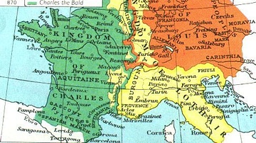
Division of the Carolingian Empire in 843 & 870 CE

Map of the Provinces of the Roman Empire under Augustus

Map of the Holy Roman Empire, 972-1032 CE
Cite This Work
APA Style
Netchev, S. (2022, September 09). Map of the Carolingian Empire under Charlemagne, c. 814. World History Encyclopedia. https://www.worldhistory.org/image/16359/map-of-the-carolingian-empire-under-charlemagne-c/
Chicago Style
Netchev, Simeon. "Map of the Carolingian Empire under Charlemagne, c. 814." World History Encyclopedia, September 09, 2022. https://www.worldhistory.org/image/16359/map-of-the-carolingian-empire-under-charlemagne-c/.
MLA Style
Netchev, Simeon. "Map of the Carolingian Empire under Charlemagne, c. 814." World History Encyclopedia, 09 Sep 2022, https://www.worldhistory.org/image/16359/map-of-the-carolingian-empire-under-charlemagne-c/.