
Server Costs Fundraiser 2026

This text is available in other languages:
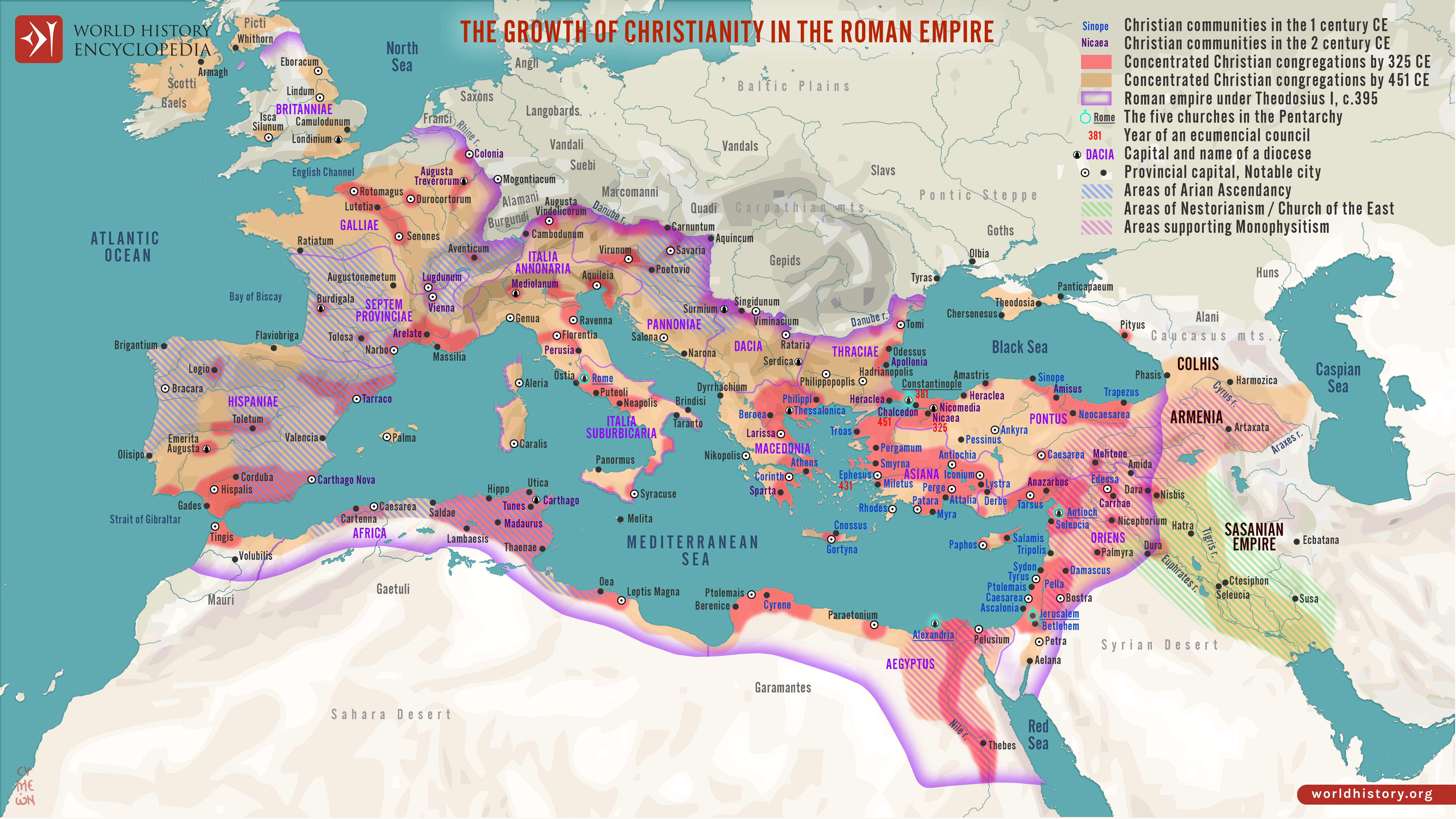
The rise and spread of Christianity (1st–5th centuries CE) traces the transformation of a small, decentralized religious movement in Roman Judea into a faith that reshaped the political, social, and cultural foundations of the Roman world. Emerging in the mid-1st century CE within a Jewish context, early Christianity spread primarily through urban networks of the eastern Mediterranean, aided by Roman roads, shared languages, and diasporic communities. Periods of persecution alternated with tolerance, but the religion’s emphasis on universal salvation, community, and moral order allowed it to take root across diverse social groups, from enslaved people to imperial elites.
A decisive shift occurred under Constantine the Great (reign 306–337 CE), whose patronage culminated in the Council of Nicaea (325 CE), an effort to impose doctrinal unity through the Nicene Creed. Christianity’s institutional authority was further consolidated under Theodosius I the Great (reign 379–395 CE), when the Edict of Thessalonica (380 CE) established Nicene Christianity as the empire’s official religion. Yet this process also intensified theological conflict. Councils such as Chalcedon (451 CE) sought to define Christ’s nature, while divergent interpretations, later labeled heretical, including Arianism, Nestorianism, and Monophysitism, spread widely across the empire and beyond. Rather than a simple story of triumph, early Christianity’s expansion reveals a complex interplay of belief, power, debate, and imperial authority that shaped both religious orthodoxy and enduring divisions within the Christian world.
About the Author

Related Images

Map of the Roman Empire under Theodosius the Great, c.395 - The Last Unified Roman Empire

Spread of Christianity Map (up to 600 CE)

Map of Constantine the Great and the Transformation of Rome - From Civil War to Christian Empire (306–337 CE)

Map of the Holy Roman Empire under Otto the Great c. 972

Map of the First Bulgarian Empire under Simeon the Great

Map of the Latin Empire: A Crusader State in Constantinople - Imperium Romaniae and the Fragmentation of Byzantium
Cite This Work
APA Style
Netchev, S. (2026, January 22). Map of the Growth of Christianity in the Roman Empire. World History Encyclopedia. https://www.worldhistory.org/image/15640/map-of-the-growth-of-christianity-in-the-roman-emp/
Chicago Style
Netchev, Simeon. "Map of the Growth of Christianity in the Roman Empire." World History Encyclopedia, January 22, 2026. https://www.worldhistory.org/image/15640/map-of-the-growth-of-christianity-in-the-roman-emp/.
MLA Style
Netchev, Simeon. "Map of the Growth of Christianity in the Roman Empire." World History Encyclopedia, 22 Jan 2026, https://www.worldhistory.org/image/15640/map-of-the-growth-of-christianity-in-the-roman-emp/.