
Illustration


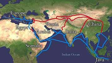
This map illustrates the shifting web of overland and maritime routes—later dubbed the “Silk Road”—that linked China, India, and Southeast Asia with Persia, the Eastern Mediterranean, and Europe. From desert caravans to monsoon-powered ships, these pathways carried silk, spices, ideas, and people long before the term itself emerged in the 19th century.
By the early Common Era, Chinese silk reached Rome via Parthian middlemen, Indian pepper spiced imperial kitchens, and Buddhist monks followed merchant trails into Central Asia. Key hubs—Chang’an, Taxila, Palmyra, Alexandria—functioned as entrepôts where camel caravans, river barges, and Red Sea dhows exchanged textiles, glass, metals, and knowledge of astronomy and medicine. Seasonal winds, shifting empires, and technological advances constantly rerouted traffic, making “the Silk Road” less a single highway than a fluid network that reshaped economies and cultures across three continents.
About the Author

Related Images

Map of the Silk Road at Its Height in the Late 8th Century
Map of the Silk Road Routes
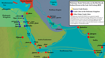
Ptolemaic Trade Networks in the Late 1st Century BCE

Map of the Roman Trade Network (1st - 3rd centuries CE)

Map of Diaspora Synagogues (1st - 2nd centuries CE)

Map of the World in the 14th Century
Cite This Work
APA Style
Netchev, S. (2022, May 04). Map of the Trade Links between Rome the East (1st - 3rd. World History Encyclopedia. Retrieved from https://www.worldhistory.org/image/15772/map-of-the-trade-links-between-rome-the-east-1st/
Chicago Style
Netchev, Simeon. "Map of the Trade Links between Rome the East (1st - 3rd." World History Encyclopedia. Last modified May 04, 2022. https://www.worldhistory.org/image/15772/map-of-the-trade-links-between-rome-the-east-1st/.
MLA Style
Netchev, Simeon. "Map of the Trade Links between Rome the East (1st - 3rd." World History Encyclopedia. World History Encyclopedia, 04 May 2022, https://www.worldhistory.org/image/15772/map-of-the-trade-links-between-rome-the-east-1st/. Web. 29 Jun 2025.