


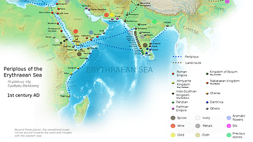
This map indicates trading routes used around the 1st century CE centred on the Silk Road. The routes remain largely valid for the period 500 BCE to 500 CE.
Related Images

Map of the Silk Road During the Late 8th Century

Map of Roman & Parthian Trade Routes

Hellenistic Trade Routes, 300 BCE

Late Medieval Land & Maritime Trade Routes
Ancient Indian Maritime Trade Routes

Trans-Saharan Trade Routes
Cite This Work
APA Style
Oceans, W. W. L. A. (2018, March 15). Map of the Silk Road Routes. World History Encyclopedia. https://www.worldhistory.org/image/8327/map-of-the-silk-road-routes/
Chicago Style
Oceans, Whole World Land And. "Map of the Silk Road Routes." World History Encyclopedia, March 15, 2018. https://www.worldhistory.org/image/8327/map-of-the-silk-road-routes/.
MLA Style
Oceans, Whole World Land And. "Map of the Silk Road Routes." World History Encyclopedia, 15 Mar 2018, https://www.worldhistory.org/image/8327/map-of-the-silk-road-routes/.