

This text is available in other languages:

Between the 7th and 4th centuries BCE, the Mediterranean functioned as a highly interconnected zone of maritime exchange, shaped by the expanding networks of Phoenician and Hellenic communities. Originating from the Levant, Phoenician traders established a chain of coastal settlements and commercial outposts across the western and southern Mediterranean, while Greek-speaking settlers founded poleis from Asia Minor to southern Italy, Sicily, and the Black Sea. These movements were not centralized imperial projects but flexible systems of trade, migration, and cultural interaction. Together, they created overlapping spheres of influence that linked distant regions, from Iberia to the eastern Mediterranean, into a shared economic and cultural space during the Archaic and early Classical periods.
These networks facilitated the circulation of key commodities, including metals from Iberia, timber, wine, olive oil, and luxury goods, while also transmitting ideas, artistic forms, and technologies such as alphabetic writing. Phoenician foundations like Carthage and Hellenic colonies across the central and eastern Mediterranean became hubs within broader exchange systems, interacting with major powers such as the Achaemenid Persian Empire (c. 550–330 BCE). At the same time, maritime routes connected with overland corridors extending into Southwest Asia and beyond, reinforcing the Mediterranean’s role as a central axis of early interregional trade.
About the Author

Related Images

Magna Graecia

Map of Trade Networks of the Late Bronze Age Mediterranean - Empires, Merchants, and Maritime Routes of the Ancient World

Map of the Trade Networks of the Roman Empire - Commerce & the Connectivity in the Mediterranean 1-3 c. CE

Phoenician Trade Network

Map of the Phoenician Trade and Colonization, c.1100-600 BCE - Trade, Colonies & Maritime Networks Across the Mediterranean
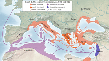
Greek and Phoenician Colonization
Cite This Work
APA Style
Netchev, S. (2026, May 03). Map of the Trade Networks of the Ancient Mediterranean World: Connectivity & Expansion in the Archaic and Classical Ages. World History Encyclopedia. https://www.worldhistory.org/image/14421/map-of-the-trade-networks-of-the-ancient-mediterra/
Chicago Style
Netchev, Simeon. "Map of the Trade Networks of the Ancient Mediterranean World: Connectivity & Expansion in the Archaic and Classical Ages." World History Encyclopedia, May 03, 2026. https://www.worldhistory.org/image/14421/map-of-the-trade-networks-of-the-ancient-mediterra/.
MLA Style
Netchev, Simeon. "Map of the Trade Networks of the Ancient Mediterranean World: Connectivity & Expansion in the Archaic and Classical Ages." World History Encyclopedia, 03 May 2026, https://www.worldhistory.org/image/14421/map-of-the-trade-networks-of-the-ancient-mediterra/.