

This text is available in other languages:
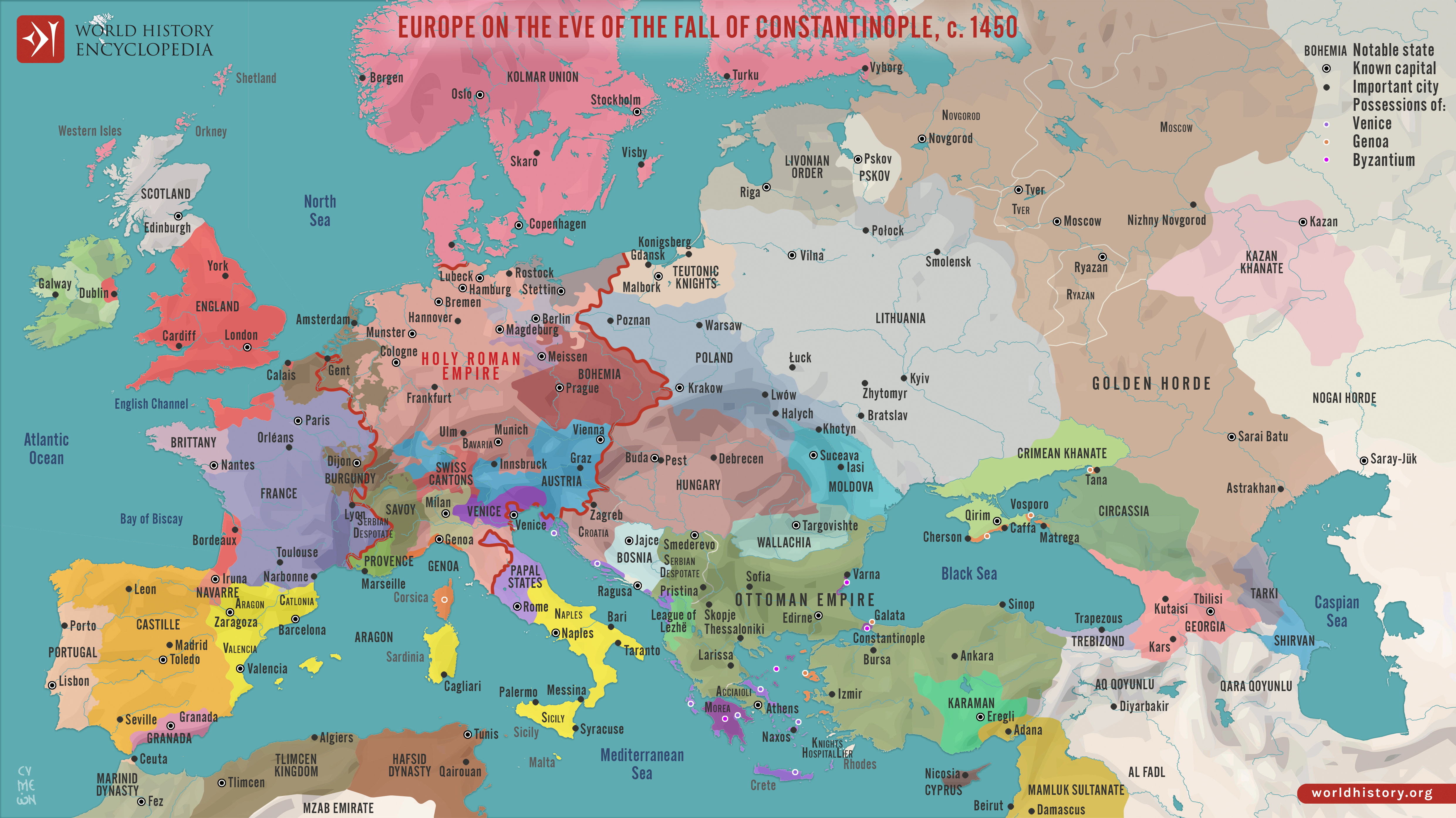
Around 1450 CE, Europe and the Middle East were defined by fragmentation, declining medieval powers, and the rise of new regional states. The Byzantine Empire had contracted to Constantinople and a few outposts, while the Ottoman Empire under Murad II (reign 1421–1451) pressed hard against its borders, setting the stage for the city’s imminent fall. In the Latin West, France emerged from the final phase of the Hundred Years’ War as a more unified monarchy under Charles VII (reign 1422–1461), and the crowns of Castile and Aragon strengthened their authority ahead of their later dynastic union. In Eastern Europe, political power remained dispersed: Moscow, Tver, Ryazan, and Novgorod operated as semi-autonomous principalities still formally linked, though unevenly, to the Golden Horde, whose authority was weakening but not yet broken. Across the Middle East, the Mamluk Sultanate held Egypt and Syria, while Qara Qoyunlu dominated much of Iran and Iraq, forming a patchwork of competing dynasties.
In the years immediately surrounding 1450, these dynamics produced rapid realignments. The Ottoman conquest of Constantinople in 1453 under Mehmed II “the Conqueror” (reign 1444–1446, 1451–1481) ended the last remnant of the Roman Empire and reshaped the balance of power in the eastern Mediterranean. Further north, the continued weakening of the Golden Horde created expansion openings for growing regional powers. Meanwhile, Western European monarchies consolidated fiscal and military institutions, laying the foundations for the more centralized states that would come to define the early modern era.
About the Author

Related Images

Map of Jeanne d’Arc's Campaigns and The Hundred Years' War - Dynastic conflict, civil war & French resurgence, 1429–53

Map of Eastern Mediterranean in 1450 CE

Map of the Ottoman Empire under Suleiman the Magnificent

The Greatest Extent of the Ottoman Empire in Europe (1683 CE)

Map of the Fall of the Western Roman Empire, c. 480 CE
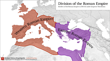
Western & Eastern Roman Empire, 395 CE
Cite This Work
APA Style
Netchev, S. (2022, February 01). Map of Europe Before the Fall of Constantinople, c. 1450. World History Encyclopedia. https://www.worldhistory.org/image/15216/map-of-europe-before-the-fall-of-constantinople-c/
Chicago Style
Netchev, Simeon. "Map of Europe Before the Fall of Constantinople, c. 1450." World History Encyclopedia, February 01, 2022. https://www.worldhistory.org/image/15216/map-of-europe-before-the-fall-of-constantinople-c/.
MLA Style
Netchev, Simeon. "Map of Europe Before the Fall of Constantinople, c. 1450." World History Encyclopedia, 01 Feb 2022, https://www.worldhistory.org/image/15216/map-of-europe-before-the-fall-of-constantinople-c/.