
Search
Remove Ads
Advertisement
Search Results

Image
Buddhist Stele, Unified Silla Kingdom
A soapstone Buddhist stele from the Unified Silla Kingdom of Korea. From the Piamsa Temple. The scene depicts Buddha and disciples with apsaras looking on. Height: 40 cm, c. 673 CE. (National Museum of Korea, Seoul, South Korea)
Image
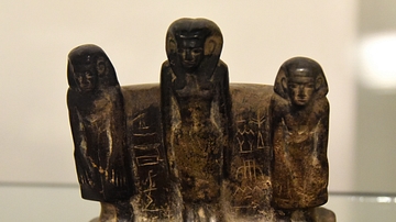
Woman & Two Sons, Middle Kingdom Statuette
This is a steatite statuette which depicts 3 standing persons. The woman stands in the middle (her name is Aa-Nubt) and her sons (Khenti-Khati-Hetep and Maat-Neferu) flank her on either side. From Egypt, precise provenance of excavation is...
Image
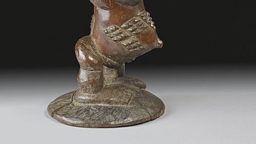
Carved Stool, Luba Kingdom
A carved wooden stool in the form of a figure from the Kingdom of Luba (15-19th century CE), central Africa. Height: 42.5 cm. (British Museum, London)

Image
Funerary Urn, Unified Silla Kingdom
A ceramic funerary urn from the Unified Silla kingdom of ancient Korea. The decoration is typical of the period and was achieved using stamps. 8th century CE. (Freer and Sackler Galleries, Washington, D.C)
Image
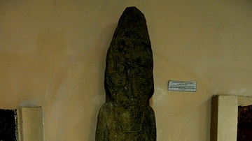
A Sandstone Statue from the Musasir Kingdom
This is one of the very few surviving artifacts from the Musasir Kingdom, 8th century BCE. It was found near Rowanduz village, modern Sulaimaniya Governorate, Iraq. The statue has lost most of its fine details because of natural erosion...

Image
Map of the Kingdom of Zimbabwe
A map indicating the approximate territory of the ancient Kingdom of Zimbabwe (in modern Zimbabwe) and its capital Great Zimbabwe. The kingdom flourished between c. 1300 and c. 1450 CE.
Image
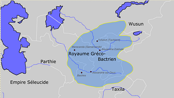
Greco-Bactrian kingdom circa 230-200 BC
Approximate borders of the Greco-Bactrian kingdom under Euthydemos' reign (c.230BC - c.200BC). The kingdom included Bactria, Oxeiana, Sogdiana and Ferghana.
Image
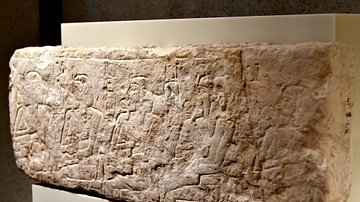
List of Five Pharaohs of the Egyptian Old Kingdom
This limestone fragment came from a New Kingdom tomb at Abusir/Saqqara, Egypt. The relief depicts five enthroned pharaohs, looking to the left. In front of the face of every one of them, a cartouche is inscribed. Only the cartouche at the...

Image
Map of the Greco-Bactrian Kingdom
Approximate maximum extent of the Greco-Bactrian kingdom circa 180 BCE, including the regions of Tapuria and Traxiane to the West, Sogdiana and Ferghana to the north, Bactria and Arachosia to the south.
Image
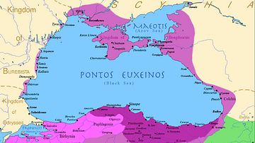
The Kingdom of Pontus
Map of the Pontic Kingdom before the reign of Mithridates VI (darkest purple), after his conquests (purple), and his conquests in the first Mithridatic wars (pink); little adds (ancient shorelines & some greek colonies under Mithridate's...