
Search
Remove Ads
Advertisement
Search Results

Image
Map of the Ptolemaic Kingdom of Egypt c. 240 BCE - Power, Wealth, and Rivalry in the Hellenistic World
By c. 240 BCE, Ptolemaic Egypt stood as one of the most powerful and stable successor states of Alexander’s empire, reaching a high point under Ptolemy III Euergetes (reign 246-222 BCE). Emerging from the fragmentation that followed the death...
Image
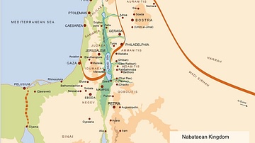
Map of the Nabatean Kingdom
Map of the Nabatean Kingdom at its greatest extent, c. 85 BCE.

Image
Map of Kingdom of Axum
A map indicating the area controlled by the African kingdom of Axum (1st-8th century CE) on the coast of the Red Sea.

Image
Map of the Macedonian Kingdom at Philip II's Death c.336 BCE - Legacy and the Road to Imperial Expansion
At the time of Philip II’s death (reign 359–336 BCE), the Kingdom of Macedon had emerged as the dominant power in the Hellenic world. Through sustained military reform, most notably the development of the Macedonian phalanx, and a combination...

Image
Map of the Zulu Kingdom and British Imperial Expansion - The Anglo-Zulu War - Conquest & the Struggle for Power
The Zulu Kingdom emerged in the early 19th century as a centralized and militarized state under Shaka Zulu (reign c. 1816–1828), whose reforms reshaped regional power dynamics in southeastern Africa. By the later 19th century, the kingdom...

Image
Map of the Middle Kingdom of Egypt, c. 2000 BCE
This map illustrates the Middle Kingdom of Egypt (c. 2055–1650 BCE), a period of reunification, stability, and cultural flourishing that followed the turbulence of the First Intermediate Period. Spanning roughly four centuries, it saw the...

Image
Map of the New Kingdom of Egypt c. 1250 BCE
The New Kingdom of Egypt (c. 1570–1069 BCE) marks the apex of ancient Egypt’s political power, territorial expansion, and imperial ambition. Emerging from the expulsion of the Hyksos and the reunification of Egypt under Ahmose I (reign c...
Image
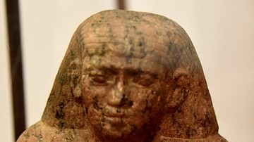
A Statuette from Old kingdom of Egypt
Only the upper half of this granite statuette of a seated man has survived. The inscriptions on the back of the statuette read "offerings given of the king to Bastet mistress of Bast for the ka of ". The inscriptions appear not to be written...
Image
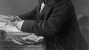
Portrait of Isambard Kingdom Brunel
A portrait of Isambard Kingdom Brunel (1806-59), the British engineer and key figure of the British Industrial Revolution (1760-1840). By John Horsley, c. 1870. (From The life of Isambard Kingdom Brunel, Civil Engineer, 1870, by Isambard...
Image
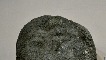
Head of a Bearded Man from the Musasir Kingdom
This is the upper part of a sandstone statue which was found near Rowanduz village, modern Sulaimaniya Governorate, Iraq. The lack of inscriptions on this statue make it difficult to determine who this bearded man was. The statue is from...