


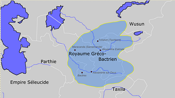
Approximate maximum extent of the Greco-Bactrian kingdom circa 180 BCE, including the regions of Tapuria and Traxiane to the West, Sogdiana and Ferghana to the north, Bactria and Arachosia to the south.
Related Images
Greco-Bactrian kingdom circa 230-200 BC

Map of the Bosporan Kingdom, c.100 CE - Gateway Between Steppe, Caucasus, and Rome

Map of the Middle Kingdom of Egypt, c. 2000 BCE

Map of the New Kingdom Egypt under Ramesses II - Egypt, Nubia, Hittites, and the Late Bronze Age c. 1250 BCE

Map of the Ptolemaic Kingdom of Egypt c. 240 BCE - Power, Wealth, and Rivalry in the Hellenistic World
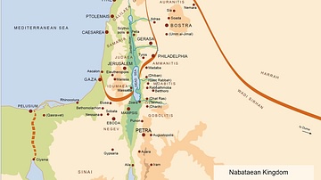
Map of the Nabatean Kingdom
Cite This Work
APA Style
PHGCOM. (2012, April 26). Map of the Greco-Bactrian Kingdom. World History Encyclopedia. https://www.worldhistory.org/image/162/map-of-the-greco-bactrian-kingdom/
Chicago Style
PHGCOM. "Map of the Greco-Bactrian Kingdom." World History Encyclopedia, April 26, 2012. https://www.worldhistory.org/image/162/map-of-the-greco-bactrian-kingdom/.
MLA Style
PHGCOM. "Map of the Greco-Bactrian Kingdom." World History Encyclopedia, 26 Apr 2012, https://www.worldhistory.org/image/162/map-of-the-greco-bactrian-kingdom/.