
Search
Remove Ads
Advertisement
Search Results

Collection
Trade in the Ancient World
Trade has been going on for as long as humans have needed or wanted something that others had and they did not. Bartering for goods and trade in kind developed into more sophisticated forms of exchanges using commonly...

Image
Map of the Trade in the Indian Ocean 15th–16th Centuries - Monsoon Routes, Spice Trade, and European Expansion
Indian Ocean trade in the 15th and 16th centuries connected East Africa, Arabia, Persia, India, Southeast Asia, and China through an extensive maritime...

Image
Map of the Trade Networks of the Roman Empire - Commerce & the Connectivity in the Mediterranean 1-3 c. CE
The prosperity of the Roman Empire (27 BCE-476 CE in the West) rested not only on military power and administration but also on an extensive network of maritime...

Image
Map of the Dutch Commercial Empire, c. 1665 - A Global Network of Commerce, Exploration and Maritime Power
A map of the Dutch commercial empire which reached its height during the Dutch Golden Age (c. 1588-1672), when the Dutch Republic (1588-1795) emerged as one...
Collection
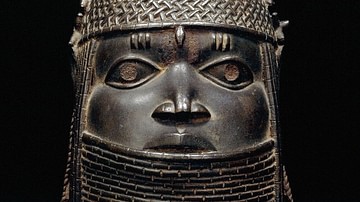
The Empires of West Africa
The ancient and medieval Mediterranean might have been a bustling stage of ever-changing empires but, across the inhospitable barrier of the Sahara Desert, West Africans were equally busy building up and toppling down...

Image
Map of the East India Company Trade, c.1800
The English East India Company (EIC) was established by Royal Charter on 31 December 1600 under Queen Elizabeth I (reign 1558–1603), granting it a monopoly on English trade east of the Cape of Good Hope...

Image
Map of the Mediterranean Trade Networks, c. 700–350 BCE - Commerce & Colonization in the Archaic and Classical Ages
Between c. 700 and 350 BCE, the Mediterranean formed part of a broad and increasingly interconnected system of maritime and overland exchange linking...

Image
Map of the Trade Networks in the Middle Ages, c. 1200
By the early 13th century (c. 1200 CE), long-distance trade networks across Eurasia and the Mediterranean had regained a level of interconnectivity not seen since late antiquity. After the political...

Image
Oldest Mural in Europe
This photo shows a reconstruction of the "Cult Wall" of Ludwigshafen, the oldest mural in Europe. The original painting was created around 3860 BCE, depicting hunting trophies of aurochs and bison, fine textiles, as well...
Image
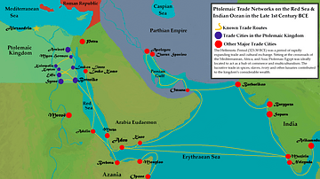
Ptolemaic Trade Networks in the Late 1st Century BCE
This map illustrates the trading networks which connected the Ptolemaic Kingdom to South Asia and East Africa by the second half of the 1st century BCE. During this time period, Ptolemaic Egypt was...
