
Search
Did you mean: Bes?
Remove Ads
Advertisement
Search Results

Image
The Byzantine Empire in the mid-9th century CE
A map of the Byzantine Empire, c. 867 CE.

Image
Umayyad Conquest, 7th & 8th Centuries CE
Map showing the Umayyad Arab (Islamic) expansion throughout the 7th and 8th centuries CE. In dark green is depicted the extent of Islam up until the death of Mohammed (622-632 CE); in the intermediate green...

Image
Battle between King Chlothar II and the Saxons, 623 CE
Depiction of the battle between King Chlothar II (r. 584-629) and the Saxons, after Chlothar II came to the aid of his son, King Dagobert I of Austrasia (r. 623-639). Illustration from the 14th-century...

Image
Anglo-Saxon Clothing, 6-9th century CE
An illustration of the typical clothing worn by Anglo-Saxons in medieval England, c. 500 - c. 1000 CE. ('Costumes of all Nations', 1882 CE)

Image
Map of Ancient Egypt, 1746 CE
This map of Egypt with information from ancient times is labeled in Latin. It shows the course of the Nile from Ancient Ethiopia and Philae all the way to the Mediterranean Sea. Place names from Hellenistic times appear...

Image
Crusader States 1200 CE
This map shows the crusader states c. 1200 CE.

Image
The Siege of Acre, 1189-91 CE
A medieval manuscript (c. 1280 CE) illustration depicting the 1189-91 CE siege of Acre during the Third Crusade. (Bibliotheque Municipale de Lyon, France)
Image
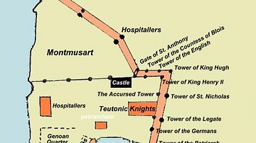
Plan of Acre, 1291 CE
A plan of the city of Acre at the time of the 1291 CE siege by the Mamluk Sultanate.

Image
Northern Crusades, 1260-1410 CE
A map indicating the territories controlled by the Teutonic Knights military order and their Crusades against pagan Europeans in the 13th and 14th century CE.
Image
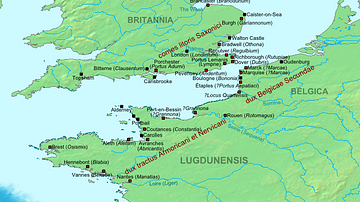
Map of the Saxon Shore, c. 380 CE
The Late Roman fortifications of the "Saxon Shore" (litus Saxonicum) in Britain and France.
