


This map of Egypt with information from ancient times is labeled in Latin. It shows the course of the Nile from Ancient Ethiopia and Philae all the way to the Mediterranean Sea. Place names from Hellenistic times appear in addition to Arabic ones. A legend provides a translation of Arabic geographical terms and explains the symbols indicating such landmarks as castles, monasteries, mosques, ruins, and cities, and spells out abbreviations used. 1746 CE Provided as part of the Traveling Classroom History Exhibit by the History in Your Hands Foundation.
Related Images

Map of Ancient Egypt
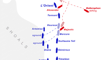
Ship Movements During the Battle of the Nile

Tigris, Euphrates, & Nile River Flows

Map of the New Kingdom Egypt under Ramesses II - Egypt, Nubia, Hittites, and the Late Bronze Age c. 1250 BCE

Map of Ancient Egypt from 1742 CE

Map of the Middle Kingdom of Egypt, c. 2000 BCE
Cite This Work
APA Style
HJBMaps, S. B. (2018, July 18). Map of Ancient Egypt, 1746 CE. World History Encyclopedia. https://www.worldhistory.org/image/9046/map-of-ancient-egypt-1746-ce/
Chicago Style
HJBMaps, Sammy Berk,. "Map of Ancient Egypt, 1746 CE." World History Encyclopedia, July 18, 2018. https://www.worldhistory.org/image/9046/map-of-ancient-egypt-1746-ce/.
MLA Style
HJBMaps, Sammy Berk,. "Map of Ancient Egypt, 1746 CE." World History Encyclopedia, 18 Jul 2018, https://www.worldhistory.org/image/9046/map-of-ancient-egypt-1746-ce/.