
9 days left
Server Costs Fundraiser 2026
It costs $20,000 a year to run our servers, and we need your help to pay for them!
$10967 / $20000


Related Images

Image
Map of Roman Gaul from Conquest to Integration, c. 200 CE - Provincial Order and Frontier Power in the Roman West
The Roman incorporation of Gaul began with the campaigns of Julius...

Image
Anglo-Saxon Map of the World
The "Cotton Map" is an Anglo-Saxon map of the world produced during...

Image
Map of Anglo-Saxon London
This is a map of Anglo-Saxon London between circa 500 CE and 1066...

Image
Map of Gaul
A map of Gaul indicating the local tribes, regions, and cities...

Image
Map of the Roman Rule in Britain c. 43 - 410 CE - Four Centuries of Empire at the Edge of the World
Roman rule in Britain developed between 43 and 410 CE, reshaping...
Image
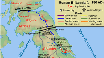
Map of Roman Britain, 150 AD
Map of Roman Britain ca. 150 AD, showing the main Roman roads...
Cite This Work
APA Style
Cplakidas. (2012, April 26). Map of the Saxon Shore, c. 380 CE. World History Encyclopedia. https://www.worldhistory.org/image/568/map-of-the-saxon-shore-c-380-ce/
Chicago Style
Cplakidas. "Map of the Saxon Shore, c. 380 CE." World History Encyclopedia, April 26, 2012. https://www.worldhistory.org/image/568/map-of-the-saxon-shore-c-380-ce/.
MLA Style
Cplakidas. "Map of the Saxon Shore, c. 380 CE." World History Encyclopedia, 26 Apr 2012, https://www.worldhistory.org/image/568/map-of-the-saxon-shore-c-380-ce/.