
Search
Did you mean: Ur?
Remove Ads
Advertisement
Search Results

Image
Map of the British Conquest in India c. 1857
This map illustrates the rapid and often chaotic expansion of British control in India between the Battle of Plassey in 1757 and the eve of the Indian Rebellion in 1857. During this century, the East India Company transformed from a trading...

Image
Map of the Empire of Timur the Lame, c. 1404 CE
This map illustrates the rise and expansion of the Timurid Empire (1370–1405) under Timur (Tamerlane), a conqueror of Turco-Mongol descent whose military campaigns reshaped the political landscape of 14th-century Eurasia. Born in 1336 near...

Image
Map of the Ptolemaic Kingdom of Egypt c. 240 BCE - Power, Wealth, and Rivalry in the Hellenistic World
By c. 240 BCE, Ptolemaic Egypt stood as one of the most powerful and stable successor states of Alexander’s empire, reaching a high point under Ptolemy III Euergetes (reign 246-222 BCE). Emerging from the fragmentation that followed the death...

Image
The Scientific Revolution (c. 1500–1700) - From Tradition to Empiricism in Early Modern Europe
The Scientific Revolution (c. 1500–1700) marks a transformative phase in European intellectual history, during which long-standing medieval frameworks were increasingly challenged by empirical observation and mathematical reasoning. Emerging...

Image
Map of Roman Gaul from Conquest to Integration, c. 200 CE - Provincial Order and Frontier Power in the Roman West
The Roman incorporation of Gaul began with the campaigns of Julius Caesar (58–51 BCE) and resulted in the gradual transformation of a diverse Celtic region into an integral part of the Roman world. By c. 200 CE, Gaul was organized into a...
Image
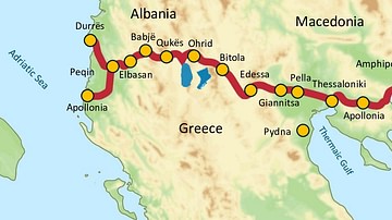
Via Egnatia, 146 BCE to c. 1200 CE
Via Egnatia was a major Roman road in the Balkans, stretching 1,120 kilometers (696 miles) from the Adriatic Sea in the west to the Black Sea and the Sea of Marmara in the east. The western terminus is slightly uncertain, often marked in...
Image
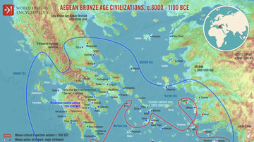
Map of the Aegean Bronze Age Civilizations, c. 3000-1100 BCE - From Minoan Maritime Exchange to Mycenaean Dominance
The Aegean world of the Bronze Age (c. 3000–1100 BCE) was shaped by shifting centers of power, interaction, and cultural exchange, most notably between the Minoan and Mycenaean civilizations. The Minoans (c. 2000–1450 BCE), based on Crete...

Image
Map of the African Slave Trade, c. 1750
By c. 1750, Africa stood at the center of three major slave-trading systems, the transatlantic, trans-Saharan, and Indian Ocean trades, each connecting African societies to wider global economies. These networks operated simultaneously but...

Image
Map of Christian Pilgrimage in the Middle Ages, c. 1000
This map illustrates the changing patterns of Christian pilgrimage during the Middle Ages: for most Europeans the long, perilous, and costly journey to the Holy Land was too far, dangerous, and forbiddingly expensive, so devotion redirected...

Image
Map of the Carolingian Empire under Charlemagne, c. 814
The rise and expansion of the Carolingian dynasty (8th–early 9th centuries CE) reached its apex under Charlemagne (reigned 768–814 CE), son of Pepin the Short (reigned 751–768 CE) and grandson of Charles Martel (d. 741 CE). Building on earlier...