
Search
Did you mean: Ur?
Remove Ads
Advertisement
Search Results
Image
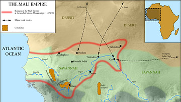
Map of the Mali Empire, c. 1337 CE
A map of the Mali Empire (1240-1645 CE) at its peak c. 1337 CE after the reign of Mansa Musa (1312-1337 CE).

Image
The First Triumvirate of the Roman Republic, c. 60-53 BCE
The First Triumvirate was an informal and secret political alliance formed in 60 BCE between three of Rome's most powerful figures: Julius Caesar, Pompey the Great, and Marcus Licinius Crassus. This alliance allowed them to bypass the Roman...

Image
Map of Roman Rule in Asia Minor, c. 200 CE
This map illustrates the geopolitical landscape of Asia Minor during the reign of Emperor Septimius Severus (193–211 CE), around the year 200 CE. By this time, the peninsula (modern-day Turkey) had been under Roman rule for more than two...

Image
Map of the World According to Christopher Columbus c. 1490
This map reflects Christopher Columbus’s (c. 1451-1506) geographical assumptions prior to his first Atlantic voyage in 1492, undertaken during the reign of the Catholic Monarchs Ferdinand II of Aragon (reign 1479-1516) and Isabella I of Castile...

Image
Map of Roman Hispania c. 125 CE
The Roman provinces in Hispania (206 BCE–c. 474 CE) illustrate both the persistence of Roman expansion and the durability of imperial rule. The conquest began in the Second Punic War, when Rome displaced Carthage in 206 BCE, and unfolded...

Image
Map of Spanish Main & West Indies c.1720 - Treasure Fleets and Imperial Competition in the 18th Century
During the 18th century, the Caribbean Sea and the Gulf of Mexico formed one of the most strategically contested regions of the Atlantic world. Initially dominated by the Spanish Empire, this maritime zone, often referred to as the Spanish...

Image
Western Classical Music, c. 1700-1950
Between c. 1700 and 1950, Western classical music evolved alongside profound political, social, and technological change, moving through four broad stylistic phases: Baroque, Classicism, Romanticism, and Modernism. The Baroque era (c. 1700–1750...
Image
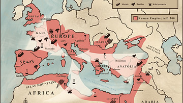
Trade in the Roman Empire Map (c. 200 CE)
This map shows the major sources of trade goods in the Roman Empire, circa 200 CE. The map shows the sources of the following trade goods: grain, olive oil, slaves, wine, metals, textiles and wild animals.
Image
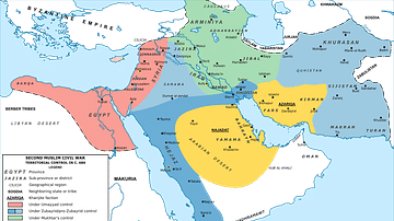
Map of the Middle East during the Second Fitna (c. 686 CE)
A map depicting the divisions of the Islamic Empire during the second Islamic civil war - the Second Fitna. The dominions of the Umayyads, Zubayrids, Kharjites, Al Mukhtar and those regained by the Byzantines are shaded in colors as indicated...

Image
Map of Elizabethan Trade with Europe, c. 1600 - Trade and Diplomacy in the Tudor World
During the reign of Queen Elizabeth I (reign 1558–1603), England underwent a decisive commercial transformation, expanding its trade networks across northern and southern Europe at a moment of shifting geopolitical and economic balance. The...