
Search
Did you mean: Ur?
Remove Ads
Advertisement
Search Results

Image
The Tomb of Tutankhamun (KV62), Thebes, c. 1323 BCE - The Boy King and the Tomb That Rewrote Egyptology
The tomb of Tutankhamun (c. 1345–1323 BCE; reign c. 1332–1323 BCE), located in the Valley of the Kings, offers a rare and largely intact snapshot of royal burial practice during Egypt’s New Kingdom (c. 1550–1070 BCE). Although Tutankhamun’s...

Image
Map of the Taifa Kingdoms of al-Andalus (c. 1031–1086) - Iberian Peninsula on the Eve of the Almoravid Intervention
The political fragmentation of al-Andalus began with the collapse of the Umayyad Caliphate of Córdoba (756–1031), culminating in its formal dissolution in 1031. In the power vacuum that followed, the Iberian Peninsula fractured into dozens...

Image
Ivan IV, the Terrible and the Tsardom of Russia, c. 1598
A map illustrating the rise and expansion of the Tsardom of Russia under the rule of Ivan IV Vasilyevich (commonly known as The Terrible, from the Russian “grozny“(грозный), Fearsome or Awe-inspiring). Originally a Grand Prince of Moscow...

Image
Map of the Roman Rule in the Levant, c. 200 CE
The Roman Levant around 200 CE, during the height of imperial consolidation under the Severan dynasty (193 - 235 CE), formed one of the empire’s most dynamic and interconnected frontier regions. Administratively divided into the provinces...
Image
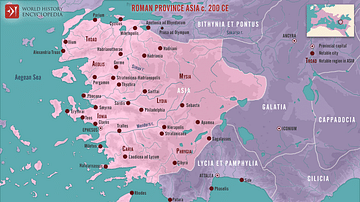
Roman Province Asia c. 200 CE
This map illustrates the Roman province of Asia around 200 CE. Established in 129 BCE following the bequest of the Attalid Kingdom of Pergamon to Rome, it encompassed western Anatolia (modern-day Turkey). It was a wealthy and vibrant region...

Image
English Medieval Clothing, c. 1300 CE
An illustration of the typical clothing worn in 14th century CE England. ('Costumes of all Nations', 1882 CE)

Image
Map of the Hittite Empire (c. 1300 BC)
Map of the Hittite Empire at its greatest extent under Suppiluliuma I(c. 1350–1322 BCE) and Mursili II (c. 1321–1295 BCE). Because many of the place names have been taken from Hittite sources and compared to classical place names, they may...

Image
Theogony (Generations of the Gods) by Hesiod, c. 700 BCE
An infographic illustrating Hesiod's Theogony (literally meaning "Birth of the Gods") - the earliest known and the only complete account of the origins of the universe and the gods according to ancient Greek mythology and tradition. Traditionally...

Image
Map of the Bosporan Kingdom, c.100 CE - Gateway Between Steppe, Caucasus, and Rome
The Bosporan Kingdom (c. 480 BCE–341 CE) emerged around the Cimmerian Bosporus (modern Kerch Strait) as a hybrid Greco-local state founded by Greek colonists from cities such as Miletus. Rather than a single unified polity in the modern sense...

Image
Map of the Hadrian’s wall (Vallum Hadriani) c. 122 CE
Hadrian’s Wall was constructed from c. 122 CE onward during the reign of Emperor Hadrian (reign 117–138 CE) as part of a broader imperial strategy to consolidate, rather than endlessly expand, Roman power. Running 73 miles (118 km) across...