


Map of the Hittite Empire at its greatest extent under Suppiluliuma I(c. 1350–1322 BCE) and Mursili II (c. 1321–1295 BCE). Because many of the place names have been taken from Hittite sources and compared to classical place names, they may not all be correct as there is still scholarly disagreement (ex. Lukka as Lycia, Karkija as Caria).
Related Images

Map of the The Mitanni (Hanigalbat) empire, c. 1600-1300 BCE - Between Egypt and the Hittites, A Kingdom of Diplomacy and War
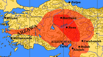
Hittite Empire c. 1300 BCE
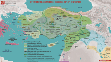
Map of the Hittite Empire 16th-13th Century BCE - Anatolian Great Power of the Bronze Age

The Ancient Near East, c. 1300 BCE - On the Eve of Collapse: Power and Politics in the Late Bronze Age

Map of the Four Khanates of the Mongol Empire, c. 1300

Ancient Near East c.1500-1300 BCE - The Old Hittite Collapse and the Rise of Kassites, Mitanni, and the New Kingdom of Egypt
References
World History Encyclopedia is an Amazon Associate and earns a commission on qualifying book purchases.Cite This Work
APA Style
Javierfv1212. (2012, April 26). Map of the Hittite Empire (c. 1300 BC). World History Encyclopedia. https://www.worldhistory.org/image/248/map-of-the-hittite-empire-c-1300-bc/
Chicago Style
Javierfv1212. "Map of the Hittite Empire (c. 1300 BC)." World History Encyclopedia, April 26, 2012. https://www.worldhistory.org/image/248/map-of-the-hittite-empire-c-1300-bc/.
MLA Style
Javierfv1212. "Map of the Hittite Empire (c. 1300 BC)." World History Encyclopedia, 26 Apr 2012, https://www.worldhistory.org/image/248/map-of-the-hittite-empire-c-1300-bc/.