
Server Costs Fundraiser 2026


The Mitanni Empire was a major Late Bronze Age power that rose in northern Mesopotamia and Upper Syria between c. 1600 and 1300 BCE, shaping the balance of power across the eastern Mediterranean world. Emerging in the political vacuum following the collapse of Old Babylonian authority, Mitanni reached its height in the 15th century BCE, functioning as a strategic intermediary between rival great powers, New Kingdom Egypt (especially under Thutmose III, reign c. 1479–1425 BCE), the Hittite Empire, and Kassite Babylonia. Through diplomacy, dynastic marriages, and military pressure, Mitanni helped stabilize long-distance exchange routes linking Anatolia, Mesopotamia, and the Levant.
Mitanni’s core lay in the Khabur River basin (modern northeastern Syria), where a predominantly Hurrian population was ruled by an elite whose royal names, treaties, and religious vocabulary reveal Indo-Aryan influences, particularly in horse training and warrior ideology. This hybrid political culture underpinned Mitanni’s military strength but also exposed its fragility. From the 14th century BCE, sustained pressure from the resurgent Hittites (notably under Šuppiluliuma I, reign c. 1344–1322 BCE) and the expanding Middle Assyrian state eroded Mitanni authority. Internal dynastic struggles further weakened the kingdom, leading to its fragmentation and eventual absorption into Assyrian and Hittite spheres by c. 1300 BCE. Mitanni’s rise and fall illustrate the volatility of Late Bronze Age geopolitics, where power depended less on territorial size than on diplomacy, military specialization, and control of strategic corridors.
About the Author

Related Images
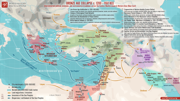
Map of the Late Bronze Age Collapse c. 1200 - 1150 BCE
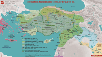
Map of the Hittite Empire 16th-13th Century BCE - Anatolian Great Power of the Bronze Age

Map of Mesopotamia, 2000-1600 BCE

Map of the New Kingdom of Egypt c. 1250 BCE

Map of the New Kingdom of Egypt, 1450 BCE

Map of India in the Vedic Age, 1500 BCE-500 BCE - Indo-Aryan Cultures in Northern India
Cite This Work
APA Style
Netchev, S. (2026, January 15). Map of the The Mitanni (Hanigalbat) empire, c. 1600-1300 BCE: Between Egypt and the Hittites, A Kingdom of Diplomacy and War. World History Encyclopedia. https://www.worldhistory.org/image/14946/map-of-the-the-mitanni-hanigalbat-empire-c-1600-13/
Chicago Style
Netchev, Simeon. "Map of the The Mitanni (Hanigalbat) empire, c. 1600-1300 BCE: Between Egypt and the Hittites, A Kingdom of Diplomacy and War." World History Encyclopedia, January 15, 2026. https://www.worldhistory.org/image/14946/map-of-the-the-mitanni-hanigalbat-empire-c-1600-13/.
MLA Style
Netchev, Simeon. "Map of the The Mitanni (Hanigalbat) empire, c. 1600-1300 BCE: Between Egypt and the Hittites, A Kingdom of Diplomacy and War." World History Encyclopedia, 15 Jan 2026, https://www.worldhistory.org/image/14946/map-of-the-the-mitanni-hanigalbat-empire-c-1600-13/.