

This text is available in other languages:

This map illustrates the rise of the Sumerian civilization in southern Mesopotamia, beginning around 6000 BCE. Situated between the Tigris and Euphrates Rivers, the region—later home to Akkad and Babylonia—saw the emergence of some of the world’s earliest urban societies built on irrigation agriculture, trade, and religious centers.
Over time, independent city-states such as Ur, Uruk, Lagash, and Eridu developed distinct governments, monumental architecture, and cuneiform writing. These communities pioneered advances in administration, law, and mathematics, while worshipping a shared pantheon of gods. Though often in conflict with each other, the Sumerians laid the foundations of Mesopotamian culture and statecraft, shaping the trajectory of ancient Near Eastern history.
About the Author

Related Images
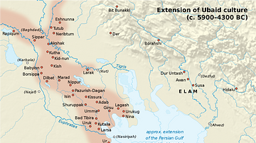
Map of Ubaid Culture

Map of the World from Sippar, Mesopotamia

Map of Sumer

Map of Sumer and Elam
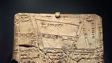
Babylonian Clay Map from Nippur

Map of the Cradles of Early Civilization - Global Pathways to Agriculture, Urban Centers & Early States
Cite This Work
APA Style
Netchev, S. (2022, March 02). Map of the Sumerian Civilization. World History Encyclopedia. https://www.worldhistory.org/image/15299/map-of-the-sumerian-civilization/
Chicago Style
Netchev, Simeon. "Map of the Sumerian Civilization." World History Encyclopedia, March 02, 2022. https://www.worldhistory.org/image/15299/map-of-the-sumerian-civilization/.
MLA Style
Netchev, Simeon. "Map of the Sumerian Civilization." World History Encyclopedia, 02 Mar 2022, https://www.worldhistory.org/image/15299/map-of-the-sumerian-civilization/.