

This text is available in other languages:

The rise of Sumerian civilization in southern Mesopotamia (c. 6000–2300 BCE) represents one of the earliest transformations from agrarian village life to urban state formation. Located between the Tigris and Euphrates Rivers, this alluvial plain required large-scale irrigation management, fostering collective organization and administrative innovation. By the fourth millennium BCE (Uruk Period, c. 4000–3100 BCE), urban centers emerged that integrated agricultural surplus, long-distance trade, temple authority, and early bureaucratic systems. The region later known as Mesopotamia, home in subsequent centuries to Akkad and Babylonia, thus became a laboratory for early statecraft, shaped by environmental adaptation and socio-political competition.
Independent city-states such as Ur, Uruk, Lagash, and Eridu developed distinct political structures under rulers often titled ensi or lugal (Early Dynastic Period, c. 2900–2334 BCE). Monumental temple complexes (ziggurats), the development of cuneiform writing (c. 3200 BCE), and advances in mathematics and law reflected increasingly sophisticated administrative needs. Although rivalry and warfare were frequent, shared religious traditions and linguistic culture fostered a broader Sumerian identity. Even after the rise of the Akkadian Empire under Sargon of Akkad (reign c. 2334–2279 BCE), Sumerian cultural models endured, shaping Mesopotamian political and intellectual life for centuries.
About the Author

Related Images
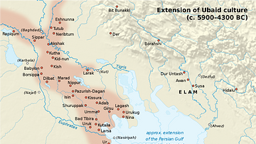
Map of Ubaid Culture

Map of the World from Sippar, Mesopotamia

Map of Sumer

Map of Sumer and Elam
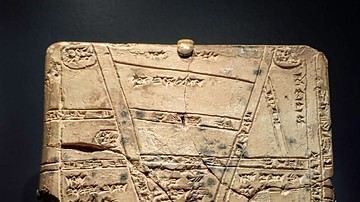
Babylonian Clay Map from Nippur

Map of Mesopotamia, 2000-1600 BCE
Cite This Work
APA Style
Netchev, S. (2026, February 27). Map of the Sumerian Civilization: Where Cities Began. World History Encyclopedia. https://www.worldhistory.org/image/15299/map-of-the-sumerian-civilization/
Chicago Style
Netchev, Simeon. "Map of the Sumerian Civilization: Where Cities Began." World History Encyclopedia, February 27, 2026. https://www.worldhistory.org/image/15299/map-of-the-sumerian-civilization/.
MLA Style
Netchev, Simeon. "Map of the Sumerian Civilization: Where Cities Began." World History Encyclopedia, 27 Feb 2026, https://www.worldhistory.org/image/15299/map-of-the-sumerian-civilization/.