


The conflicts commonly known as the English Civil Wars form part of the wider Wars of the Three Kingdoms, a series of interconnected struggles across England, Scotland, and Ireland. These wars unfolded during the reign of Charles I of England (reign 1625–1649) and were rooted in disputes over royal authority, taxation, and the religious settlement of the Stuart kingdoms. What began as a political crisis between king and Parliament in England expanded into a multi-kingdom conflict, shaped by differing confessional priorities, Anglican, Presbyterian, and Catholic, and by competing visions of sovereignty. The overlapping nature of these disputes meant that the wars cannot be understood as a single civil conflict, but rather as a series of linked wars across a composite monarchy.
Fighting took place across multiple theatres, involving Royalists defending monarchical authority and a range of opponents, including English Parliamentarians, Scottish Covenanters, and Irish Confederate forces. Alliances shifted frequently as political and religious priorities evolved, producing a highly fluid and complex conflict. The eventual defeat of the Royalist cause led to the trial and execution of Charles I in 1649 and the establishment of a republican regime under Oliver Cromwell (Lord Protector 1653–1658). This interlude, known as the Commonwealth and later the Protectorate, marked a significant, if temporary, departure from monarchy, before the restoration of Charles II of England (reign 1660–1685) in 1660.
About the Author

Related Images
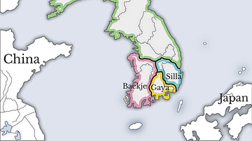
Three Kingdoms of Korea Map

Map of the American Civil War, 1861-1865
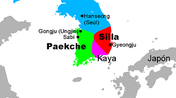
Three Kingdoms, Korea

Later Three Kingdoms Period
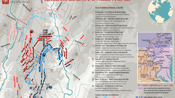
Map of Battle of Gettysburg during the American Civil War
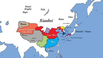
Three Kingdoms Period of China and the Rise of Xianbei in the year 229 CE
Cite This Work
APA Style
Netchev, S. (2026, March 25). Map of the Wars of the Three Kingdoms: Britain in Civil War (1642–1651). World History Encyclopedia. https://www.worldhistory.org/image/15295/map-of-the-wars-of-the-three-kingdoms/
Chicago Style
Netchev, Simeon. "Map of the Wars of the Three Kingdoms: Britain in Civil War (1642–1651)." World History Encyclopedia, March 25, 2026. https://www.worldhistory.org/image/15295/map-of-the-wars-of-the-three-kingdoms/.
MLA Style
Netchev, Simeon. "Map of the Wars of the Three Kingdoms: Britain in Civil War (1642–1651)." World History Encyclopedia, 25 Mar 2026, https://www.worldhistory.org/image/15295/map-of-the-wars-of-the-three-kingdoms/.