Illustration
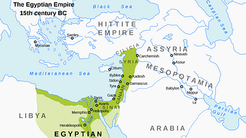
This map illustrates the political landscape of Ptolemaic Egypt in 240 BCE, during the reign of Ptolemy III Euergetes (reigned 246–222 BCE), a period often considered the kingdom’s peak in terms of military strength, economic prosperity, and regional influence. Now eight decades after the death of Alexander the Great (d. 323 BCE), Egypt had become one of the most stable and powerful of the Hellenistic successor states, ruled from the cultural and administrative capital of Alexandria.
The broader eastern Mediterranean was still shaped by the legacy of Alexander’s conquests, as his generals—known as the Diadochi—had divided his empire into competing dynasties. By 240 BCE, three enduring Hellenistic kingdoms had emerged: Antigonid Macedonia, Ptolemaic Egypt, and the Seleucid Empire in Asia. Of these, the Ptolemaic dynasty would prove the most enduring, surviving nearly three centuries. Though Egypt eventually fell under Roman influence, it remained nominally independent until 30 BCE, when it was formally annexed following the death of Cleopatra VII Philopator (reigned 51–30 BCE), the last active ruler of the Ptolemaic line.
About the Author
Cite This Work
APA Style
Netchev, S. (2022, January 25). Map of Ptolemaic Egypt c. 240 BCE. World History Encyclopedia. Retrieved from https://www.worldhistory.org/image/15183/map-of-ptolemaic-egypt-c-240-bce/
Chicago Style
Netchev, Simeon. "Map of Ptolemaic Egypt c. 240 BCE." World History Encyclopedia. Last modified January 25, 2022. https://www.worldhistory.org/image/15183/map-of-ptolemaic-egypt-c-240-bce/.
MLA Style
Netchev, Simeon. "Map of Ptolemaic Egypt c. 240 BCE." World History Encyclopedia. World History Encyclopedia, 25 Jan 2022, https://www.worldhistory.org/image/15183/map-of-ptolemaic-egypt-c-240-bce/. Web. 30 Jun 2025.


