
Search
Remove Ads
Advertisement
Search Results

Image
Routes of the Underground Railroad
Routes of the Underground Railroad, a network of secret routes and safe havens to help slaves escape, illustration from The underground railroad from slavery to freedom by Wilbur Henry Siebert, 1898.

Image
Map of the Trade Networks of the Roman Empire - Commerce & the Connectivity in the Mediterranean 1-3 c. CE
The prosperity of the Roman Empire (27 BCE-476 CE in the West) rested not only on military power and administration but also on an extensive network of maritime and overland trade routes that connected communities across Europe, North Africa...
Definition
Natchez Trace
Natchez Trace is a historic site and park in the United States commemorated by the Natchez Trail Parkway stretching 444 miles (715 km) from Natchez, Mississippi, through northern Alabama, to Nashville, Tennessee, roughly adhering to a series...

Lesson Pack
Geography, Economy, & Trade in Ancient Egypt
We have prepared three lesson plans including classroom activities, assignments, homework, and keys as well as: - Multiple choice quiz questions in an excel format. - Glossary of keywords and concepts in an excel format. - Open questions...

Definition
Mali Empire
The Mali Empire (1240-1645) of West Africa was founded by Sundiata Keita (r. 1230-1255) following his victory over the kingdom of Sosso (c. 1180-1235). Sundiata's centralised government, diplomacy and well-trained army permitted a massive...

Definition
Portuguese Angola
Portuguese Angola in southwest Africa was the first European colony on that continent. While settlement from 1571 proved problematic in the interior, the Portuguese did obtain a large number of slaves which they shipped to their Atlantic...
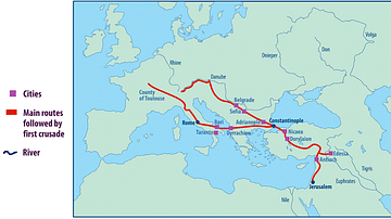
Image
Map of the First Crusade Routes
"This map shows the main routes taken by those who joined the First Crusade. The appeal was made by Pope Urban II in November 1095 CE but crusaders did not set out until the following summer. One route went through Hungary crossing the Byzantine...

Article
Caesarea Maritima's Role in the Roman Empire
Caesarea Maritima, the city Herod the Great (r. 37-4 BCE) built for Rome on the southeastern coast of the Mediterranean served as the Roman Empire's powerbase of operations both commercially and militarily. With Rome's ultimate goal of adding...

Image
Routes of the Barbarian Invaders
Routes of the Barbarian invaders into the Roman Empire during the Migration Age.

Image
Sea Routes from Ancient Japan to China
A map illustrating possible sea routes used for political and cultural embassies from ancient Japan to Tang Dynasty China.