
Search
Remove Ads
Advertisement
Search Results

Definition
Oyo Empire
The Oyo Empire flourished from the 17th to 19th century CE in what is today southwest Nigeria. The Oyo forged an empire thanks to their formidable cavalry units and so came to dominate other Yoruba peoples of the region. The Oyo Empire, with...

Image
Phoenician Trade Network
Map of Phoenicia and its trade routes.

Image
African Slave Trade, c. 1500-1900
African Slave Trade, map by KuroNekoNiyah, 2021. This map provides an overview of the slave trade out of Africa, c. 1500-1900, showing both transatlantic and ancillary global flows. It is based on Map I from Atlas of the Transatlantic Slave...

Definition
Dutch East India Company
The Dutch East India Company (VOC) was formed in 1602 by the Staten-Generaal (States General) of the then Republic of the Seven United Netherlands. The company was granted a 21-year charter with rights to trade exclusively in Asia and to...

Definition
Estado da India
The Estado da India (1505-1961) was the name the Portuguese gave to that part of their empire which stretched from India to East Asia. However, in its widest sense, the name includes all Portuguese colonies east of the Cape of Good Hope and...

Image
Trade in the Roman Empire Map (c. 200 CE)
This map shows the major sources of trade goods in the Roman Empire, circa 200 CE. The map shows the sources of the following trade goods: grain, olive oil, slaves, wine, metals, textiles and wild animals.

Definition
Silk in Antiquity
Silk is a fabric first produced in Neolithic China from the filaments of the cocoon of the silk worm. It became a staple source of income for small farmers and, as weaving techniques improved, the reputation of Chinese silk spread so that...

Definition
Portuguese Nagasaki
Nagasaki, on the northwest coast of Japan’s Kyushu Island, was an important Portuguese trading base from c. 1571 to 1639, and the most eastern outpost of the Portuguese empire. The Portuguese presence transformed Nagasaki from a small fishing...

Definition
Canaan
Canaan was the name of a large and prosperous ancient country (at times independent, at others a tributary to Egypt) located in the Levant region of present-day Lebanon, Syria, Jordan, and Israel. It was also known as Phoenicia. The origin...
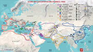
Image
Second-Wave Civilization Natural Resources and Trade
A map illustrating the rise and spread of the Second Wave Civilizations between c. 500 BCE and 200 CE (including the Persians, the Greeks, the Romans, the Chinese, and India) with the flows of trade in major goods and resources.