
Search
Remove Ads
Advertisement
Search Results
Image
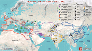
Second-Wave Civilization Natural Resources and Trade
A map illustrating the rise and spread of the Second Wave Civilizations between c. 500 BCE and 200 CE (including the Persians, the Greeks, the Romans, the Chinese, and India) with the flows of trade...

Article
Ming Taxation & the Silver Economy
The rulers of China's Ming dynasty (1368-1644) acquired an insatiable desire for silver in the 16th century, largely to pay for huge prestige projects like building the Forbidden City in Beijing and repairing the...

Definition
Wolof Empire
The Wolof (aka Jolof or Djolof) Empire was a state on the coast of West Africa, located between the Senegal and Gambia rivers, which thrived from the mid-14th to mid-16th century CE. The empire prospered on trade thanks to the two...

Video
How Roman Trade with India Made the Empire Rich
This video was sponsored by Imperator: Rome. You can support our channel by buying this game via this link: https://store.steampowered.com/app/859580/Imperator_Rome/ We are continuing our new animated...

Image
Map of Medieval Japanese Trade & Wako Pirates
Map depicting Medieval Japan and its trade relations with its neighbours, China and Korea. The map shows the major trade goods exchanged between Japan, China, and Korea. Black lines show the approximate...

Video
The Silk Road and Ancient Trade: Crash Course World History #9
The Silk Road and Ancient Trade: In which John Green teaches you about the so-called Silk Road, a network of trade routes where goods such as ivory, silver, iron, wine, and yes, silk were exchanged...

Image
Slave Trade
Execrable Human Traffick, or The Affectionate Slaves, oil on canvas by George Morland, c. 1788. Depicted here is a scene of a man being abducted by slavers on the coast of Africa as his family watches. From the 16th to the 19th century...

Image
Map of the Phoenician Trade and Colonization, c.1100-600 BCE - Trade, Colonies & Maritime Networks Across the Mediterranean
Between c. 1100 and 600 BCE, the Phoenician city-states of the Levant, especially Tyre, Sidon, Byblos, and Arwad, developed one of the ancient...

Image
Map of Elizabethan England Trade with Europe, c. 1600 - Commerce, Companies & Expansion under Elizabeth I
Elizabethan England's trade with Europe around 1600 formed part of a changing early modern commercial system in which established regional networks coexisted...

Video
The Silk Road: Trade Route of the Ancient World
The Silk Road was a network of trading routes that connected a number of different regions in the ancient world, stretching over four thousand miles from China, through India and Asia Minor and through...
