
Search
Remove Ads
Advertisement
Search Results

Image
World War II in Europe, November 1942
A map depicting the strategic situation in Europe and the Mediterranean in early November 1942, as World War II reached a critical turning point. Axis expansion had begun to reverse, while the Allies launched major offensives in North Africa...

Image
The "Spring of Nations": Revolutionary Europe in 1848 - From Revolution to Reaction: Nationalism and Upheaval in Nineteenth-Century Europe
This map illustrates the sweeping republican revolts and political upheavals that erupted across Europe in 1848, a year known as the People's Spring or the Spring of Nations. Part of a broader continuum of revolutionary movements since the...

Image
Map of the Spread of the Plague in Europe, 1346 - 1353
This map illustrates the spread of the 14th-century plague pandemic, the “Black Death,” which swept across Europe and the Middle East between 1346 and 1353. Originating in Central Asia, it traveled on merchant vessels carrying grain and furs...

Image
Map of Europe after the War of the Austrian Succession, 1748 - Dynastic Rivalry and Balance of Power
The War of the Austrian Succession (1740–1748) reshaped the political balance of Europe after the death of Charles VI, Holy Roman Emperor (reign 1711–1740) and the contested accession of Maria Theresa (reign 1740–1780) to the Habsburg lands...
Image
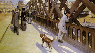
The Pont de l'Europe by Caillebotte
An 1876 oil on canvas, The Pont de l'Europe, by Gustave Caillebotte (1848-96) the French impressionist painter. Caillebotte uses the strong diagonal of the railway bridge to draw the viewer's eye down the street, following the dog. Such industrial...
Image
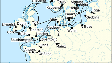
Viking Age Trade Routes in North-West Europe
Map showing some of the Viking Age (c. 790-1100 CE) trade routes that existed in North-West Europe during this time. Among the places depicted are such major trading centres are Hededy, Ribe, Birka and Kaupang from Viking Scandinavia; York...

Image
Shaft-Hole Axe from Early Dynastic Period
This shaft-hole axe dates back to the early dynastic period,2800-2350 BCE, Mesopotamia, Iraq. (The Sulaimaniya Museum, Iraq).

Image
Map of the Russian Civil War in Europe (1917–1922)
The Russian Civil War (1917–1922) was a multi-front conflict that followed the collapse of the Russian Empire and the Bolshevik seizure of power. After Lenin’s October Revolution in 1917, the Bolsheviks withdrew from World War I with the...

Image
Map of the World War I in Europe, May 1917
A map illustrating the situation in Europe around May 1917, during the First World War (World War I or The Great War), as the conflict had already raged on for nearly three years. The United States had recently entered the war, beginning...

Image
Memorial to the Murdered Jews of Europe
A view of the Memorial to the Murdered Jews of Europe, a memorial in Berlin to the Jewish victims of the Holocaust (1941-1945), from the Ministergärten. Designed by New York architect Peter Eisenman, the memorial covers 19,000 square metres...