
Search
Search Results

Image
New England, 1665 CE
Map of New England printed by John Seller John in 1675 CE, based on William Reed's original survey of 1665 CE.

Image
New World Native Plants
New World native plants. Clockwise, from top left: 1. Maize (Zea mays); 2. Tomato (Solanum lycopersicum); 3. Potato (Solanum tuberosum); 4. Vanilla (Vanilla); 5. Pará rubber tree (Hevea brasiliensis); 6. Cacao (Theobroma cacao); 7...
Image
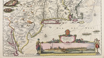
Map of New Netherland
Map of the New Netherland colonies c. 1696 and 1701 CE, by Justus Danckerts. Collection of the Municipal Library of Trento.
Image
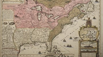
Map of New France
A map produced in 1719 showing New France. The pink area marks the territory of Canada.

Image
LZ 129 Hindenburg over New York
The German Zeppelin airship LZ 129 Hindenburg flying over New York, c. 1936.
Image
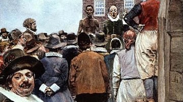
First Slave Auction in New Amsterdam, 1655 CE
"Slave Auction, 1655: First Slave Auction in New Amsterdam" by Howard Pyle, 1895 CE.
Image
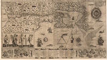
Map of New France, 1612 CE
Map of New France 1612 CE by Samuel de Champlain (1567?-1635 CE).
National Library of France.

Image
New Orleans Battle Map
A depiction of the British assault during the Battle of New Orleans (8 Jan 1815). By the History Dept. of the United States Military Academy.

Image
Gibbs' Assault at the Battle of New Orleans
Maj. Gen. Samuel Gibbs' British assault against the American position at 'Line Jackson' during the Battle of New Orleans (8 Jan 1815), lithograph by Kurz & Allison, 1890.
Library of Congress, Washington, D.C.

Image
Battle of New Orleans
A 1910 print by Edward Percy Moran of the Battle of New Orleans. On 8 January 1815, the U.S forces, commanded by General Andrew Jackson, successfully defended the city against an attack by a British force. (Library of Congress)