
Search
Remove Ads
Advertisement
Search Results

Image
Map of Romani Migration in the Middle Ages
Map showing the movement of the Romani people between approximately 500 and 1500 CE. The dates used on this map are commonly accepted approximations based on historical accounts and linguistic evidence. Some...
Image
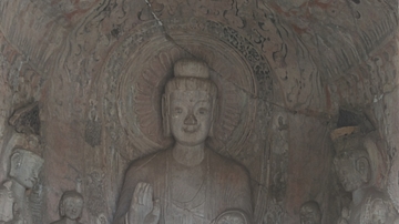
Longmen Grottoes - Middle Binyang Cave
Early Northern Wei style grotto at Longmen Grottoes, Henan Province, China. c. 500 CE

Image
Ancient Near East c.1500-1300 BCE - The Old Hittite Collapse and the Rise of Kassites, Mitanni, and the New Kingdom of Egypt
This map illustrates the geopolitical landscape of the ancient Near East following the destructive campaigns of the Old Hittite Empire (circa...

Image
The Ancient Near East, c. 1300 BCE - On the Eve of Collapse: Power and Politics in the Late Bronze Age
This map illustrates the shifting political landscape of the Ancient Near East in the 13th century BCE, a period marked by the rise of imperial powers and the...

Image
Map of the Ancient Near East after Hammurabi, c. 1700 BCE - Kingdoms, Cities & Shifting Power in the Bronze Age
By c. 1700 BCE, the political landscape of the Ancient Near East had been reshaped by the rapid rise and fragmentation of two unusually large territorial...

Image
Map of the East India Company Trade, c.1800
The English East India Company (EIC) was established by Royal Charter on 31 December 1600 under Queen Elizabeth I (reign 1558–1603), granting it a monopoly on English trade east of the Cape of Good Hope...

Definition
Ancient Egyptian Literature
Ancient Egyptian literature comprises a wide array of narrative and poetic forms including inscriptions on tombs, stele, obelisks, and temples; myths, stories, and legends; religious writings; philosophical works; wisdom...

Collection
The History of The East India Company
The British East India Company (EIC) was founded as a trading company in 1600. Run by a board of directors in London, the company employed a private army, first to protect the trade it conducted in the Indian...

Image
East Asia in the year 1 CE
This map shows the boundaries of all major civilizations in East Asia at the beginning of the first millennium, with italics indicating nomadic bands and other tribal societies.

Image
East Asia circa 300 CE
This map shows all major civilizations of East Asia at the beginning of the 3rd century CE. Italicized texts indicate nomadic bands or tribal societies.
