
Search
Remove Ads
Advertisement
Search Results
Image
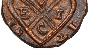
Copper Coin of the East India Company
A copper coin minted by the British East India Company (EIC). From Bombay, 1821.

Image
Dutch East India Company Logo
Blue and white Dutch East India Company (Vereenigde Oostindische Compagnie or VOC) logo from 1650-1674. Made in Japan to order by the company's directors in Batavia (Jakarta). Date between 1615 and 1674.

Image
East India Company Trooper & Sepoy
An 1839 illustration showing a trooper and sepoy (Indian recruit) of the East India Company army. 27th Regiment of Madras Native Infantry. (British Library, London)

Image
Maji-Maji Rebellion, German East Africa
An early-20th-century painting by Wilhelm Kuhnert depicting German-led African Askari troops at the Battle of Mahenge during the Maji-Maji Rebellion (1905-7) against colonial rule in German East Africa.

Image
Pieter de Carpentier - Governor General of the Dutch East Indies
Pieter de Carpentier (1586-1659) - Governor General of the Dutch East Indies.

Image
Maryland, Dutch East Indies
A Swiss plantation in the Dutch East Indies bought in 1881 by Karl Krüsi (1855–1925) and named after Mary, his wife. In 1893, he sold it for a fortune and built the Villa Sumatra Zurich’s Sumatrastrasse. Manager House in Deli, Karl Krüsi...

Image
19th-Century Ivory Traders, East Africa,
An 1880s photograph of ivory traders in East Africa.

Video
The Reason Why People Died So Young In The Middle Ages
Reasons why such low estimates for life expectancy during the MIddle Ages are often tossed around. From infant mortality skewing the stats, to the risks of childbirth and disease.

Definition
Crusader States
The Crusader States (aka the Latin East or Outremer) were created after the First Crusade (1095-1102) in order to keep hold of the territorial gains made by Christian armies in the Middle East. The four small states were the Kingdom of Jerusalem...

Definition
Freya Stark
Freya Stark (l. 1893-1993) was an English explorer, writer, and political influencer who chronicled world events, especially in the Near East, throughout the 20th century. Stark both reported on and made the news as her travels, described...