
Search
Remove Ads
Advertisement
Search Results

Image
Map of the Hellenic Leagues and Hegemonies, 4th century BCE
The political landscape of the Hellenic world shifted dramatically in the aftermath of the Peloponnesian War (431–404 BCE), a conflict that ended with Sparta’s victory but left the Greek city-states militarily exhausted and politically fragmented...

Image
Map of the Early Christian Pilgrimage (4th-5th Century)
The rise of Christian pilgrimage begins after the conversion of Emperor Constantine (reign 306–337 CE) and the legalization of Christianity in the Edict of Milan (313 CE). The word pilgrim comes from the Latin peregrinus meaning “stranger”...
Image
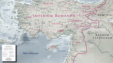
Asia Minor in the Early 1st Century CE
Map of Asia Minor in the early 1st century CE with the Kingdom of Commagene as a Roman client state.
Image
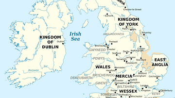
British Isles at the Beginning of the 10th Century
British Isles in 10th century represented with the coastline at the time.

Image
European 16th Century Armour
Typical weapons and armour used in European warfare in the 16th century and by conquistadors in the New World. (Grand Master's Palace Armoury, Valletta, Malta)
Image
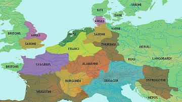
Central Europe 5th century CE
Map showing central Europe in the 5th century CE.
Image
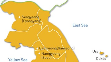
Map of the Goryeo Empire (11th century CE)
A map of the territory controlled by the Goryeo Dynasty of Korea in the 11th century CE. The Goryeo reigned from 918 to 1392 CE.

Image
Knights in Armour, 15th century CE
Knights in armour typical of the 15th century CE. (Metropolitan Museum of Art, New York)

Image
16th Century Morion Helmet
A typical steel morion helmet, a type worn across Europe in the 16th century and worn by conquistadors in the New World. Italian, c. 1570. (Metropolitan Museum of Art, New York)
Image
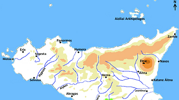
Map of Greek Sicily, 5th Century BCE
A map indicating the principal towns in Sicily during the 5th century BCE.