
Search
Remove Ads
Advertisement
Search Results

Image
11th century CE Kievan Rus Territories
Map of Kievan Rus territories during the feudal split, after the death of Prince Yaroslav the Wise in 1054 CE.

Image
16th Century CE Flemish Book Printer
An illustration of a Flemish printer's shop, Impressio Librorum. Made in Antwerp, 1580-1605 CE. (British Museum, London)
Image
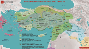
Map of the Hittite Empire 16th-13th Century BCE - Anatolian Great Power of the Bronze Age
The Hittite Empire emerged in central Anatolia during the early second millennium BCE and developed into one of the major powers of the Late Bronze Age. Centered on Hattusa, it ruled over a culturally diverse realm rooted in the older land...

Image
The Military Crusader Orders, 11-13 Century
An infographic showing the Military Crusader Orders which emerged as unique institutions blending monastic devotion with martial duty. Founded in the wake of the First Crusade (1096–1099), their primary purpose was to protect pilgrims and...

Image
Anglo-Saxon Clothing, 6-9th century CE
An illustration of the typical clothing worn by Anglo-Saxons in medieval England, c. 500 - c. 1000 CE. ('Costumes of all Nations', 1882 CE)
Image
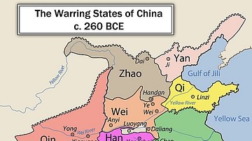
Chinese Warring States, 3rd century BCE
A map showing the principle state of the Warring States Period in China c. 260 BCE.

Image
Map of Celtic Expansion - 6th-3rd century BCE
A map showing the various campagins of Celtic tribes between the 6th and 3rd centuries BCE.
Image
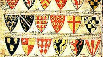
13th Century CE Roll of Arms
The oldest known English roll of arms, dating to c. 1244 CE. It is a single sheet painted on both sides by Mathew Paris and showing 75 coats of arms starting with the king’s. (British Library, London)

Image
The Byzantine Empire in the mid-9th century CE
A map of the Byzantine Empire, c. 867 CE.

Image
15-century CE Nautical Map
Nautical chart of the North-East Atlantic Ocean, the Baltic Sea, the Mediterranean Sea and the Black Sea, accompanied by a circular world map.
Alleged author: Cristopher Columbus (l. 1451-1506 CE)
Gallica Digital Library