


A map indicating the principal towns in Sicily during the 5th century BCE.
About the Author

Related Images

Map of the Migration Period in Europe in the 4th-5th Century

Map of the Early Christian Pilgrimage (4th-5th Century)

Map of the Greek City-states c. 500 BCE

Map of Settlement & Mobility in the Aegean, c. 1100-550 BCE - Migration, Memory, and the Making of the Hellenic World

Map of the Hellenic Leagues and Hegemonies, 4th century BCE
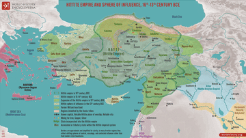
Map of the Hittite Empire 16th-13th Century BCE - Anatolian Great Power of the Bronze Age
Cite This Work
APA Style
Piccolo, S. (2017, December 19). Map of Greek Sicily, 5th Century BCE. World History Encyclopedia. https://www.worldhistory.org/image/7776/map-of-greek-sicily-5th-century-bce/
Chicago Style
Piccolo, Salvatore. "Map of Greek Sicily, 5th Century BCE." World History Encyclopedia, December 19, 2017. https://www.worldhistory.org/image/7776/map-of-greek-sicily-5th-century-bce/.
MLA Style
Piccolo, Salvatore. "Map of Greek Sicily, 5th Century BCE." World History Encyclopedia, 19 Dec 2017, https://www.worldhistory.org/image/7776/map-of-greek-sicily-5th-century-bce/.