
Browse Content
Image
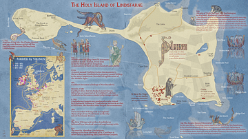
The Holy Island of Lindisfarne
A map illustrating the geography and history of Holy Island, also known as Lindisfarne. A tidal island off the northeast...

Image
Map of The D-Day and the Normandy Landings, June 1944 - Operation Overlord & History's Largest Amphibious Invasion
The Allied landings in Normandy on 6 June 1944...

Image
Fort Ticonderoga Layout, 1758
A map showing the layout of Fort Ticonderoga (known as Fort Carillon at the time) in 1758, around the time of the Battle...

Image
Map of the Great Sioux Reservation 1868
Map of the Great Sioux Reservation as established by the Fort Laramie Treaty of 1868, what was lost after the...

Image
Battle of Guilford Court House, Battle Map
Map depicting the Battle of Guilford Court House (15 March 1781) by Richard Harvey, 2006.

Image
Map of the Mali Empire under Mansa Musa, c.1337 - Power, Gold, and the Trans-Saharan Trade Network
The Mali Empire (c. 1235 - c. 1672) emerged in the western Sahel...
