
Search Images
Browse Content (p. 1674)

Image
Brahma, Cambodian Statue
A sandstone statue of the Hindu god Brahma. The god is in typical pose with four faces representing his creation of the four Vedas in Hindu mythology. 1.20 m tall. Cambodia, 10th century CE. (Metropolitan Museum of Art, New York)

Image
Brahma, Chiang Mai
A depiction of the Hindu Creator god Brahma. The god is frequently depicted with four faces representing safety, fortune, blessing, and compassion. Chiang Mai, Thailand.
Image
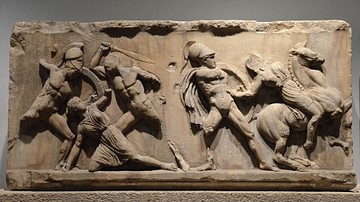
Amazonomachy Relief from the Mausoleum at Halicarnassus
Slab from the Amazonomachy frieze depicting five figures, three Greeks and two Amazons, and a horse. From the Mausoleum at Halicarnassus, around 350 BCE (British Museum).

Image
The Ruins of the Mausoleum at Halicarnassus
The ruins of the Mausoleum of Halicarnassus in Caria (now Bodrum in Turkey), constructed for King Maussollos during the mid-4th century BCE. Its construction was so beautiful and unique that it became one of the Seven Wonders of the Ancient...
Image
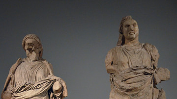
Colossal Statues of Mausolus and Artemisia II
Colossal statues of a man and a woman from the Mausoleum at Halicarnassus, traditionally identified as Mausolus and Artemisia II, around 350 BCE. (British Museum, London)

Image
Göbekli Tepe
The 10,000 BCE temple of Göbekli Tepe, Turkey.
Image
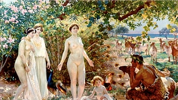
The Judgement of Paris
The painting shows the Judgment of Paris, an event in Greek mythology. Figures, from left to right: The goddesses Athena, Hera and Aphrodite, then Aphrodite's son, Eros, and Paris.
Oil on canvas, 1904. Museum of Málaga.
Image
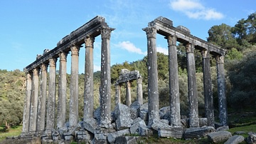
Temple of Zeus, Euromos
The temple of Zeus Lepsynus at Euromos, located in the ancient region of Caria, is one of the best preserved temples in Turkey. The temple was built in the Corinthian order in the 2nd century CE (probably during the reign of the emperor Hadrian...

Image
Ephesus terrace houses: Mosaics and Art
The terrace homes in Ephesus give a glimpse of how the wealthy lived during the Roman period The oldest building dates back into the 1C BCE and continued in use as a residence until the 7C CE.

Image
Ephesus Terrace Houses: Floor Plan
The terrace homes in Ephesus give a glimpse of how the wealthy lived during the Roman period The oldest building dates back into the 1C BCE and continued in use as a residence until the 7C CE.