
Search Images
Browse Content (p. 1673)
Image
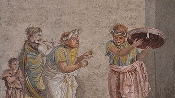
Mosaic with Musicians
Mosaic depicting musicians, signed by Dioskourides of Samos. The mosaic shows an episode from a comedy since the figures are wearing theatrical masks. The figures are playing musical instruments often connected with the cult of Cybele: the...
Image
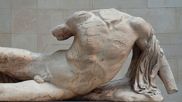
Figure of a River God, Parthenon
Marble statue from the West pediment of the Parthenon (West pediment A) depicting a river-god (possibly the river Ilissos), designed by Pheidias, about 438-432 BCE. (British Museum, London)
Image
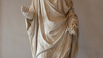
Roman Goddess Flora
Flora was the Roman goddess of flowers, vegetation and fertility. Spring was her season and her temple stood near the Circus Maximus in Rome. Her festival, called the Floralia, was instituted in 238 BCE. This Roman artwork from the Hadrianic...

Image
She-wolf mosaic
Mosaic depicting the She-wolf with Romulus and Remus, inspired by the legend of the founding of Rome. From Aldborough (UK), about 300-400 CE (Leeds City Museum).
Image
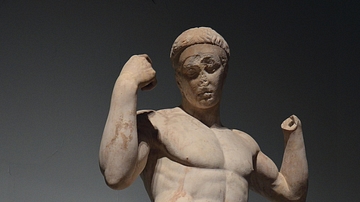
Victorious Athlete: The Vaison Diadumenos
Statue known as the Vaison Diadumenos (ribbon wearer) depicting an athlete tying a victor's ribbon around his head. It was found at the Roman theatre of Vaison-la-Romaine (France). Hadrianic copy (2nd century CE) after a 5th century BCE original...

Image
Female Gladiators
Marble relief with female gladiators, from Halicarnassus (modern Bodrum, Turkey), 1st-2nd century CE. The British Museum, London. This marble relief commemorates the honourable release from service (missio) of two women fighters, "Amazon"...
Image
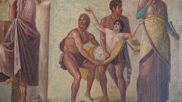
The Sacrifice of Iphigenia
Fourth Style fresco depicting the Sacrifice of Iphigenia, from the House of the Tragic Poet in Pompeii. 1st century CE. (Naples National Archaeological Museum) Iphigenia is dragged to the altar as a sacrificial offering to Artemis. On either...

Image
Fresco with Wounded Aeneas
Fresco depicting Iapyx removing an arrowhead from Aeneas' thigh. Venus stands over while beside Aeneas stands his young son Ascanius. 1st century CE (between 45 and 79 CE), from Pompeii. (Naples National Archaeological Museum).
Image
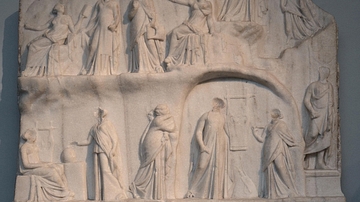
The Apotheosis of Homer
Marble relief depicting the Apotheosis (elevation to divine status) of the poet Homer with Zeus, Apollo and the Muses, signed by the sculptor Archelaus of Priene, ca. 225-205 BCE, found in Italy but thought to have been sculpted in Egypt...
Image
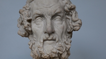
Portrait of Homer
Marble portrait bust of the blind poet Homer with Greek letters carved on each side, Antonine copy (2nd century CE) of a Hellenistic original of the 2nd century BCE, found 1780 near Baiae (Italy). Now in the British Museum.